Uluru: Anangu People and Living Tjukurpa Law, Sacred Monolith Geology, Sunrise and Sunset Light Show, Kata Tjuta Valley of the Winds, Kings Canyon Rim Walk, and Complete Practical Guide with Cultural Respect
Uluru: the sacred monolith (geology, dimensions, joint management since 1985), the Anangu people and Tjukurpa living law, Uluru sunrise and sunset transitions (Field of Light installation), Kata Tjuta the Many Heads (Valley of the Winds walk, sacred significance), Kings Canyon Rim Walk and Lost City, and the complete practical guide including cultural protocols, photography restrictions, and the climbing ban.
- 1
Uluru - the Sacred Heart of Australia
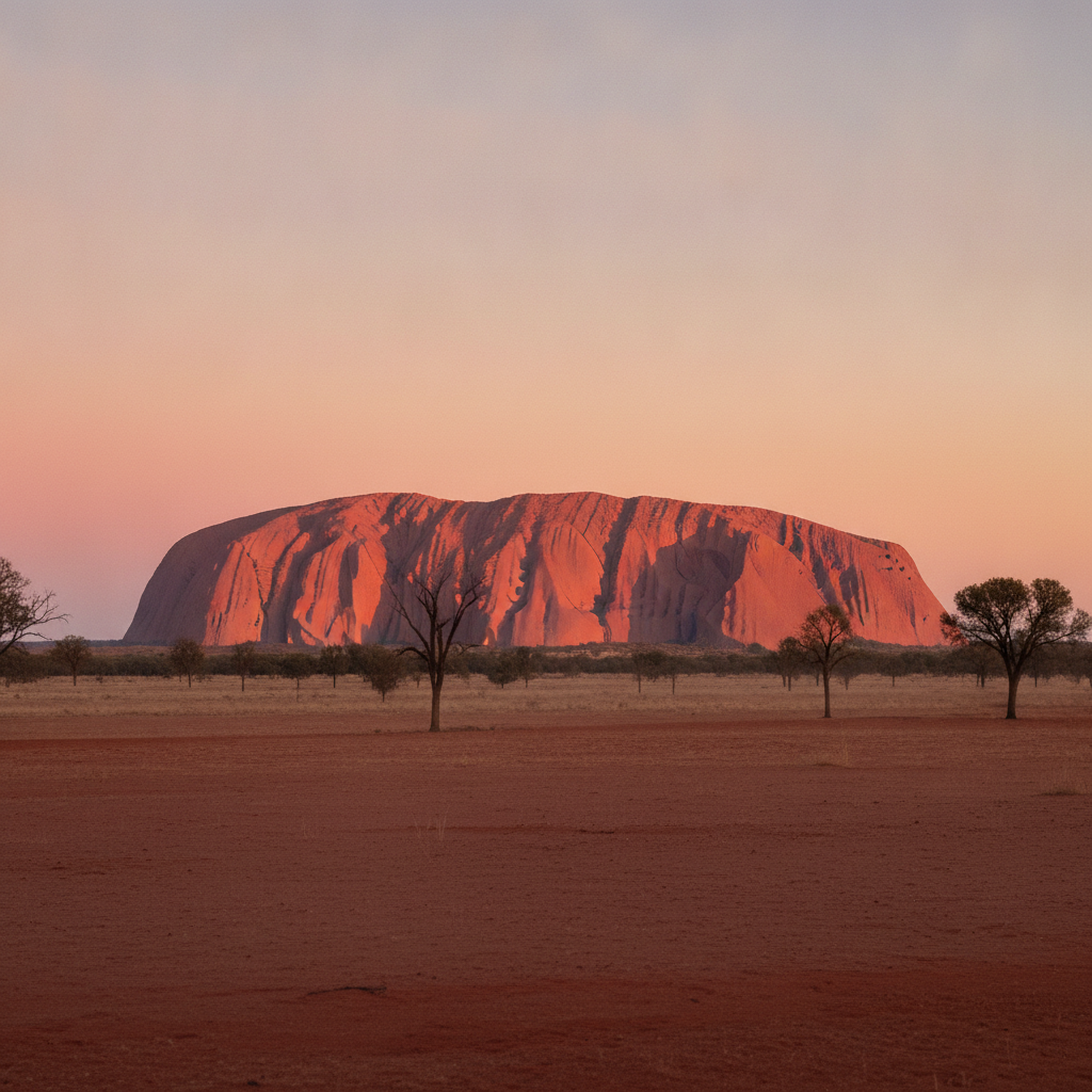
Uluru (Ayers Rock in the colonial name, but Uluru in the Anangu Pitjantjatjara language): the sandstone monolith in the Northern Territory of Australia, 335 km southwest of Alice Springs. Uluru is the single most recognizable natural icon of Australia and one of the most recognizable geological formations on earth. Uluru dimensions: 348 m above the surrounding plain (the base is at 863 m above sea level), 9.4 km in circumference, and 3.6 km long by 1.9 km wide. The rock visible above ground is only the tip of a much larger structure; the full sandstone formation extends approximately 6 km underground. Uluru geology: the arkosic sandstone was formed approximately 550 million years ago from a sheet of sediment deposited in an ancient inland sea; the sediment layer was then tilted almost vertically by tectonic forces. The Uluru-Kata Tjuta National Park (UNESCO World Heritage Site 1987, listed for both natural and cultural values): jointly managed by the Anangu traditional owners and the Australian Government (Parks Australia) since 1985. The joint management arrangement: the Uluru-Kata Tjuta board of management has a majority of Anangu members, reflecting the fundamental principle that the Anangu are the primary custodians and decision makers for the park.
- 2
The Anangu People and Tjukurpa - the Law of the Land
The Anangu (the Aboriginal people of the Western Desert region, the traditional owners of Uluru-Kata Tjuta): the Anangu have lived in the Uluru area for at least 10,000 years (archaeological evidence from Uluru establishes a minimum occupation of 10,000 years; oral traditions and the depth of the Tjukurpa suggest a much longer connection). The Tjukurpa (the Anangu traditional law, cosmology, and history): the Tjukurpa (sometimes translated as the Dreaming but this translation is inadequate) is the foundational law that governs the relationship between the Anangu, the land, the animals, and the spiritual beings that created the landscape. The Tjukurpa is not merely a creation story; it is a living law governing behaviour, land management, and social relations. The Uluru Tjukurpa: the physical features of Uluru (the caves, the waterholes, the erosion channels, the rock faces) each have specific Tjukurpa stories; many of these stories are restricted and cannot be shared outside of the Anangu ceremonial context. The Anangu cultural obligation: the Anangu feel a deep obligation (inma) for the care and protection of Uluru and the park; the traditional land management practices (patch burning, plant harvesting, and water source maintenance) are integrated into the modern park management. The Anangu language: Pitjantjatjara is the primary language spoken by the Anangu at Uluru, one of the most widely spoken Indigenous Australian languages.
- 3
Uluru Sunrise and Sunset - the Light Show of the Red Centre
The Uluru sunrise experience: the sunrise at Uluru is one of the most celebrated natural light events in Australia. At first light, the rock transitions from a deep mauve through burgundy to a vivid orange-red as the sun rises above the horizon. The sunrise viewing area (the car park on the eastern side of the rock, with the dedicated sunrise viewing platforms): the best unobstructed view of the eastern face of Uluru as it catches the first sun. The Uluru sunset experience (the sunset viewing area on the western side of the rock, with the telescoping viewing platforms): the rock transitions through orange, red, deep crimson, and purple before disappearing in the post-sunset darkness. The Uluru Field of Light (the installation by artist Bruce Munro, which ran from 2016 to 2020 and was so popular it was extended multiple times): 50,000 solar-powered stems of light illuminating the desert floor around Uluru in the darkness before dawn; the Field of Light sold out months in advance and was one of the most popular art installations in Australian history. The meaning of colour: the red colour of Uluru is caused by the iron oxide (rust) coating on the surface of the sandstone; rain reveals the true grey colour of the rock beneath the iron crust.
- 4
Kata Tjuta - the Many Heads More Sacred Than Uluru
Kata Tjuta (the Olgas in the colonial name, meaning many heads in the Anangu language): the group of 36 domed rock formations 25 km west of Uluru, within the Uluru-Kata Tjuta National Park. Kata Tjuta dimensions: the highest dome (Mount Olga, Kata Tjuta central peak) rises 546 m above the surrounding plain, 200 m higher than Uluru. The total area of Kata Tjuta (3,500 hectares) is actually larger than the visible area of Uluru. Kata Tjuta geology: formed from the same ancient sediment sheet as Uluru but from a different sediment type (conglomerate: a mix of pebbles, cobbles, and boulders cemented by sand and clay); the conglomerate is tilted at approximately 20-30 degrees (less steep than the near-vertical Uluru arkose). The Kata Tjuta significance to the Anangu: the Anangu regard Kata Tjuta as even more sacred and restricted than Uluru; the primary Kata Tjuta Tjukurpa stories are the most restricted of any in the park and are not shared with outsiders at all. The Valley of the Winds walk (7.4 km circuit, 3-4 hours, the primary Kata Tjuta walk): the walk through the gorges and valleys between the domes, passing the Karu lookout and the Karingana lookout. The Walpa Gorge walk (2.6 km return, 1 hour, the accessible alternative): the shorter walk into the main gorge of Kata Tjuta.
- 5
Kings Canyon and Watarrka National Park
Kings Canyon (Watarrka National Park, approximately 300 km northeast of Uluru, 3.5 hours by road): the red sandstone canyon with the 100 m vertical walls and the sandstone domes of the Lost City. The Kings Canyon Rim Walk (6 km circuit, 3-4 hours): the primary walk at Kings Canyon, climbing the steep Heartbreak Hill at the start and then following the rim of the canyon with views into the 100 m depth, passing the Garden of Eden (the sheltered rock pool with cycad palms and native figs at the head of the canyon). The Lost City section of the Rim Walk: the extraordinary maze of sandstone domes eroded into round shapes resembling a ruined city; the domes are formed by the preferential erosion of the cross-bedding planes in the sandstone. Kings Canyon Creek Walk (the alternative 2.6 km return walk through the canyon base): the accessible walk at the bottom of the canyon. The Watarru community (the small Anangu community near Kings Canyon): the traditional owners of the Watarrka area; the community owns and manages the Kings Canyon Resort. The Ernest Giles Road (the unsealed road between Kings Canyon and Uluru, 300 km): the shortcut connecting the two major Red Centre attractions, accessible by conventional 2WD in dry conditions. The Kings Canyon Rim Walk health warning: the climb is steep and strenuous; the walk is closed if the temperature exceeds 36 degrees C (a frequent occurrence in summer).
- 6
Uluru Practical Guide - Getting There, Staying Nearby, and Cultural Respect
Getting to Uluru: Ayers Rock Airport (AYQ, 6 km from the Ayers Rock Resort): the airport serves Uluru with direct flights from Sydney (3 hours), Melbourne (3.5 hours), Brisbane (3.5 hours), and Cairns (3 hours). Alternative overland: Alice Springs (335 km northeast of Uluru, 4 hours by road): the Stuart Highway south from Alice Springs to Erldunda junction, then the Lasseter Highway west to Uluru. The Ayers Rock Resort (the only accommodation base for visiting Uluru): the resort township of Yulara, 18 km from Uluru, with accommodation from the luxury Sails in the Desert Hotel (AUD 500-1,000 per night) to the campground (AUD 40-50 per night). The cultural protocols at Uluru: the climbing ban (the Anangu have requested that visitors not climb Uluru since 1985; the climbing was permanently closed in October 2019 due to the sacred nature of the site and the safety risk). The photography restrictions: certain sections of Uluru and Kata Tjuta have photography restrictions due to the sacred nature of the sites; the signs and the information in the cultural centre indicate which areas are restricted. The Uluru Cultural Centre (at the base of Uluru, near the Mala Walk car park): the primary information resource on the Tjukurpa and the Anangu culture. Uluru best season: May to September (the dry season, with mild days 20-25 degrees C and cold nights); October to April is extremely hot (40-45+ degrees C) with occasional heavy rain.