Pulau Ubin: Singapore's Last Kampong
Pulau Ubin, a 10.2-square-kilometer island off the northeast tip of Singapore's mainland accessed by a 12-minute bumboat ride from Changi Point Ferry Terminal, is the last inhabited island off Singapore's coast and the only place in Singapore where the pre-development kampong (village) landscape survives: a landscape of secondary forest, mangrove swamps, coastal wetlands, granite quarries, and scattered Malay and Chinese kampong houses that has been largely unchanged since the 1970s, when Singapore's government froze development on the island pending a decision on its long-term use. The island has a permanent population of approximately 100 people (down from 3,000 in the 1980s), bicycle rental shops at the bumboat jetty, and no cars (the island's only vehicles are the National Parks Board trucks and the bumboat taxis). The Chek Jawa Wetlands (a 100-hectare coastal wetland on the island's eastern tip, containing six distinct ecosystems — mangrove forest, coastal forest, seagrass lagoon, sandy beach, rocky beach, and coral rubble) is one of the most biodiverse areas in Singapore, saved from development in 2001 by a successful last-minute public campaign against a planned land reclamation that would have destroyed the wetlands.
- 1
Changi Point Ferry Terminal — The Departure from Singapore
Changi Point Ferry Terminal, a small concrete jetty on the northeastern tip of Singapore's main island (accessible by bus from Tanah Merah MRT, approximately 45 minutes from the city center), is the departure point for bumboats to Pulau Ubin: small wooden motorboats that carry 12 passengers across the Serangoon Harbour between Singapore and the island, a 12-minute crossing. The bumboats depart when full (not to a schedule), cost S$4 per person each way (one of the few remaining examples of truly affordable public transportation in Singapore), and have been making the same crossing since the island was an active quarry supplying granite for Singapore's construction industry in the early 20th century. The crossing at dawn or dusk provides views of the Straits of Johor (the narrow channel between Singapore and Malaysia), the causeway to Malaysia at Woodlands visible in the distance, and occasionally the otters and kingfishers that inhabit the mangrove shores.
- 2
Ubin Town — The Last Kampong Village
Ubin Town, the small settlement at the island's western end where the bumboat jetty is located, contains the highest concentration of functioning kampong life remaining in Singapore: a handful of shophouses (built approximately 1920s–1950s) operating as bicycle rental shops, a coffee shop serving kopi and traditional food, a Chinese temple (Fo Shan Ting Da Bo Gong, dedicated to the Earth God, with a prayer hall that is an authentic example of the Teochew Chinese folk religion practice that was common throughout Singapore in the mid-20th century), a seafood restaurant, and a cluster of approximately 30 remaining kampong houses (wooden stilt houses on cleared land within the forest, most occupied by elderly residents who have lived on the island their entire lives). The bicycle rental (approximately S$5–15 per day depending on the bicycle quality, from simple single-speed bikes to geared mountain bikes) is the primary means of exploring the island.
- 3
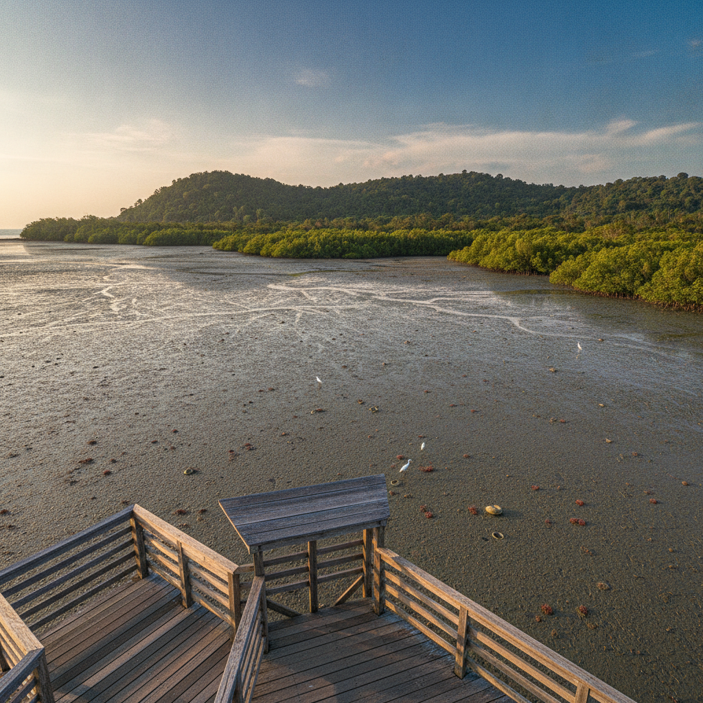
Chek Jawa Wetlands — Six Ecosystems at the Edge of the Sea
Chek Jawa Wetlands, the 100-hectare intertidal area at the eastern tip of Pulau Ubin, is the most biodiverse coastal area in Singapore and one of the most significant intertidal ecosystems in the region: a site where six distinct coastal and marine ecosystems meet within a single 100-hectare area — mangrove forest (dominated by Rhizophora mucronata mangrove trees, their arching prop roots visible above the waterline), coastal forest (containing several species of trees found nowhere else in Singapore), seagrass lagoon (Chek Jawa's sheltered bay contains Singapore's last remaining significant seagrass meadow, habitat for dugongs that historically fed in these waters), sandy beach, rocky shore (populated with sea anemones, sea cucumbers, and horseshoe crabs — the latter a 'living fossil' species unchanged for 450 million years that breeds on Chek Jawa's beaches), and coral rubble. The area was scheduled for land reclamation in 2001 but was saved when a group of biologists, led by Ivan Nessler, organized a public campaign and discovery walks that revealed the unexpected richness of the ecosystem to Singapore's government, resulting in a 10-year development moratorium (later extended indefinitely).
- 4
Pekan Quarry and the Granite Legacy
Pekan Quarry, a flooded granite quarry in the center of Pulau Ubin (now a freshwater lake of approximately 0.5 hectares, surrounded by the secondary forest of the island's interior), is the most visible surviving evidence of the island's primary historical industry: granite quarrying, which was the economic foundation of Pulau Ubin from the mid-19th century until the 1970s, when cheaper granite from Malaysia and Indonesia made the Ubin quarries uneconomic. Pulau Ubin's name derives from the Malay word for granite (batu ubin means 'quarry stone'), and the island's granite was used in the construction of many of Singapore's colonial-era public buildings, the original Causeway connecting Singapore and Malaysia (1923), Horsburgh Lighthouse (1851), and portions of the Singapore waterfront reclamation projects that extended the city's land area in the 19th and early 20th centuries. The abandoned quarry pits, now filled with fresh water and surrounded by secondary forest, have become habitats for monitor lizards, freshwater fish, and migratory waterbirds.
- 5
Ketam Mountain Bike Park — The Island's Red Trails
Ketam Mountain Bike Park, a network of mountain bike trails in the northwestern portion of Pulau Ubin (accessible by cycling approximately 3 kilometers from Ubin Town along the main road), is Singapore's only mountain bike park and one of Southeast Asia's most technically demanding purpose-built trail systems: approximately 10 kilometers of single-track trails through the island's secondary forest, classified from beginner to advanced, with features including rock gardens, wooden bridges, technical drops, and a summit viewpoint overlooking the Straits of Johor and Johor Bahru in Malaysia. The park was built by volunteers from Singapore's mountain biking community who cleared, graded, and maintained the trails over several years, and is managed jointly by the National Parks Board and the Singapore Mountain Bike Association. The trails are best ridden in the dry season (November–March) when the laterite soil is firm; in the monsoon season (May–October) the trails become slippery and several sections close.
- 6
Noordin Beach and the Wild Coast
Noordin Beach, a small sandy beach on Pulau Ubin's northern coast accessible by bicycle along a rough track from the main road (approximately 4 kilometers from Ubin Town), is the most remote and least visited beach on the island: a short stretch of coarse grey sand backed by coastal forest, facing the Johor Straits and the mangrove shores of Malaysia's Johor Bahru across 2 kilometers of water. The beach is named for a Malay kampong community that settled here in the 19th century and is the only beach on Pulau Ubin where visitors might have the shore entirely to themselves — a rare experience in one of the world's most densely populated countries. Nordim Village, a small cluster of kampong houses in the forest above the beach, is the most isolated inhabited settlement in Singapore, accessible only by bicycle or on foot. The northern shore of Pulau Ubin is the best place in Singapore for birdwatching, with migratory species using the island as a stopover on the East Asian-Australasian Flyway.