Cerro San Cristóbal, the Andes Panorama & Santiago's Natural Setting
Santiago (the capital of Chile — population approximately 7.1 million in the greater metropolitan area, the political, cultural, and economic capital of the country that stretches 4,300 km (2,670 miles) along the Pacific coast of South America): Cerro San Cristóbal (the 880-metre hill that rises above the Barrio Bellavista neighbourhood north of the city centre, crowned by the Virgen de la Inmaculada Concepción and offering the most spectacular panoramic view of the Andes Mountains of any major South American city) is the defining natural landmark of Santiago.
- 1
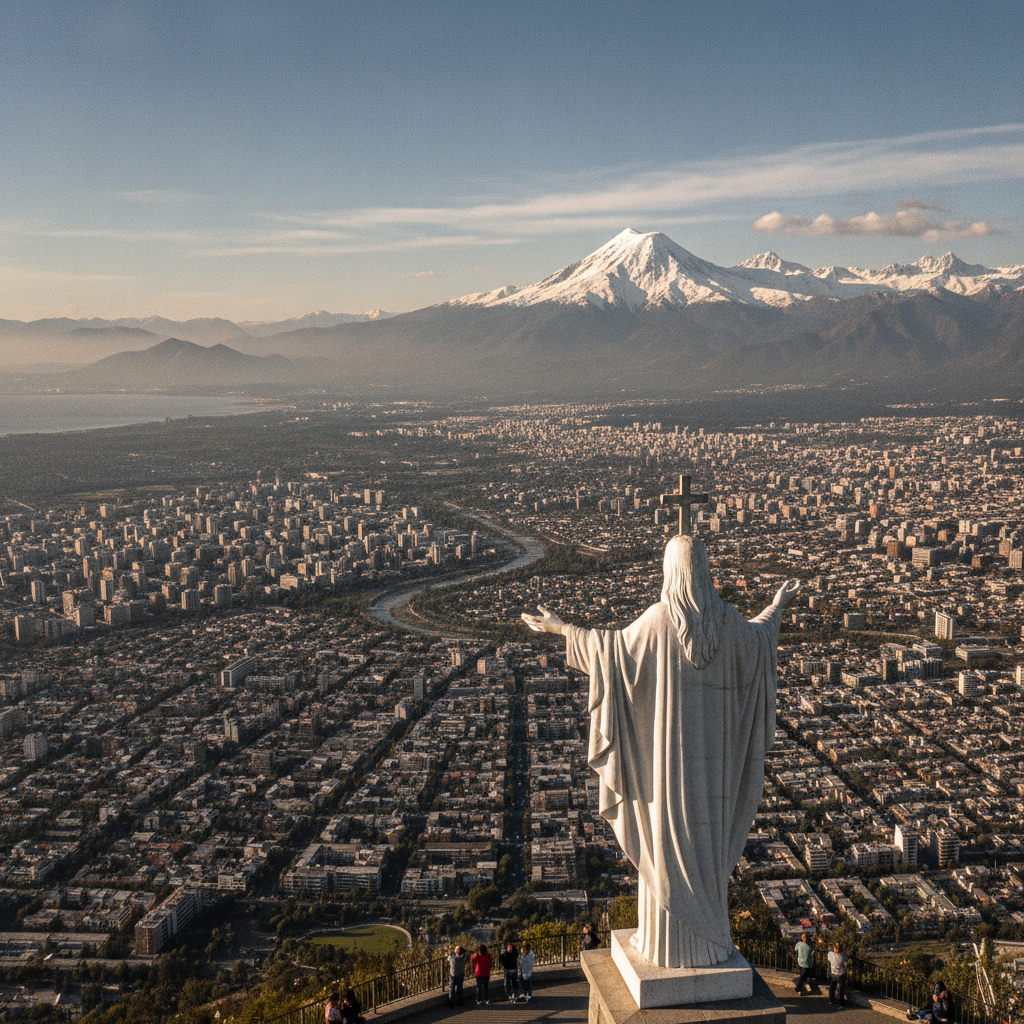
Cerro San Cristóbal Summit & the Virgen
Cerro San Cristóbal (the hill that dominates the northern skyline of Santiago — the 880-metre (2,887-foot) hill that is the highest point of the Parque Metropolitano de Santiago (the 722-hectare metropolitan park that covers the hill and its surrounding slopes, the largest urban park in Chile and the largest urban park in South America)): the Virgen de la Inmaculada Concepción (the 14-metre (46-foot) white marble statue of the Virgin Mary at the summit, consecrated on December 8, 1908 by Bishop Florencio Fontecilla — the statue that is the most prominent visual landmark on the Santiago skyline when viewed from the city below, visible from virtually every point in the city on clear days): the Funicular del Cerro San Cristóbal (the funicular railway that ascends from the Barrio Bellavista (the 'Pedro de Valdivia' lower station) to the summit of the hill — the funicular built 1925, operating on a track of 485 metres (1,591 feet) at a maximum gradient of 68%): the summit panorama (the 360-degree panoramic view from the summit — the Andes Mountains immediately to the east (the snow-capped peaks of the Main Andes, rising to 6,000-7,000 metres in the volcanic arc above Santiago), the Santiago Basin spread below (the flat urban fabric of the city filling the Mapocho River valley from the Andes to the Coastal Mountains), and the Coastal Mountains (the Cordillera de la Costa — the lower mountain range, reaching approximately 2,000 metres (6,600 feet), that separates Santiago from the Pacific coast and the port city of Valparaíso).
- 2
Parque Metropolitano & Santiago's Green Lungs
The Parque Metropolitano de Santiago (the 722-hectare metropolitan park covering the Cerro San Cristóbal and the adjacent hills of Cerro Pirámide, Cerro Chacarillas, and Cerro Los Gemelos — the park that is the largest urban park in South America and the most important recreational green space in the Santiago metropolitan area): the park facilities (the two swimming pools (Piscina Tupahue (the upper pool, at 860 metres elevation on the Cerro San Cristóbal) and Piscina Antilén (the lower pool)), the Santiago Zoo (the Zoológico Nacional de Chile — the national zoo of Chile, established 1925, with 3,000 animals representing 1,000 species, located on the slopes of Cerro San Cristóbal below the summit), the Jardín Japonés (the Japanese Garden donated to Chile by the Japanese government in 1967), and the network of hiking and cycling trails that traverse the park): the Mapocho River (the river that flows along the southern base of Cerro San Cristóbal through the city of Santiago — the Mapocho (from the Mapudungun language: 'place of many waters') that originates in the Andes glaciers east of Santiago and flows west through the city to join the Maipo River south of Santiago — the river whose seasonal flooding shaped the history of the city from its founding in 1541 through the construction of the tajamar (the flood control walls) in the colonial period).
- 3
Barrio Bellavista — Santiago's Bohemian Neighbourhood
Barrio Bellavista (the neighbourhood immediately south of Cerro San Cristóbal, between the Mapocho River and the hill — the most bohemian and culturally vibrant neighbourhood in Santiago): the Bellavista character (the neighbourhood that has been the centre of the arts, literary, and nightlife culture of Santiago since the early 20th century — the neighbourhood of the studios of Chilean artists, the houses of Chilean poets, the art galleries, the restaurants, and the bars that make Bellavista the most visited neighbourhood in Santiago for its arts and culture): the Pablo Neruda connection (the 'La Chascona' — the house of Pablo Neruda (1904-1973) (the Chilean Nobel laureate poet — the winner of the 1971 Nobel Prize in Literature, the most celebrated Spanish-language poet of the 20th century and the most internationally recognised Chilean in history) at Fernando Márquez de la Plata 0192, Barrio Bellavista — the house Neruda built in 1953 for his third wife, Matilde Urrutia, hidden in a maze of narrow paths on the hillside below Cerro San Cristóbal): the Bío-Bío street market (the outdoor antique and second-hand market on the Avenida Bío-Bío in Barrio Bellavista — the most important second-hand market in Santiago).
- 4
Andes Mountains & Santiago's Ski Resorts
The Andes Mountains east of Santiago (the Cordillera Principal — the main chain of the Andes Mountains that forms the eastern boundary of the Santiago metropolitan area, rising from the city's eastern suburbs to peaks of 6,000-7,000 metres (20,000-23,000 feet) in distances of 50-80 km (31-50 miles) from the city centre): the Santiago ski resorts (the cluster of ski resorts in the Andes above Santiago — the closest ski resorts to any South American capital): Valle Nevado (the largest ski resort in South America, at 3,025-3,670 metres (9,925-12,040 feet) elevation, 60 km (37 miles) east of Santiago on the Las Leñas road — the resort with 7 lifts and 29 runs, the resort most visited by international ski tourists in South America): El Colorado / Farellones (the ski resort cluster of El Colorado, Farellones, and La Parva in the Farellones Valley, 40 km (25 miles) east of Santiago at 2,400-3,333 metres (7,874-10,935 feet) elevation — the most accessible ski resorts for Santiago residents (45-60 minutes by car from the city centre on non-snowfall days)): Portillo (the legendary ski resort 145 km (90 miles) north of Santiago at 2,880 metres (9,449 feet) elevation on the road to Mendoza, Argentina — the resort famous for being the venue of 5 FIS Alpine Ski World Cup speed events and the preferred resort of serious international ski racers and enthusiasts).
- 5
Mapocho River & Parque Forestal
The Mapocho River (the river that flows west-to-east through the centre of Santiago — the river whose banks (the 'riberas del Mapocho') constitute the linear park system that runs through the centre of the city from the Parque de los Reyes in the west through the Parque Forestal to the Parque Balmaceda in the east): the Parque Forestal (the linear park along the south bank of the Mapocho River between the Parque de los Reyes and the Barrio Lastarria — the park planted with trees donated by European countries at the 1910 Centennial Exhibition (the exposition held in Santiago in 1910 to celebrate the centennial of Chilean independence), the park that is now the most popular urban park in central Santiago): the Mercado Central (the covered public market at the Puente Cal y Canto metro station on the south bank of the Mapocho River — the Neo-Classical iron structure built 1872 and now housing the restaurants and fishmongers that serve Santiago's finest fresh seafood (the Pacific swordfish (the 'albacora'), the conger eel (the 'congrio' — the most important fish in Chilean gastronomy, the fish immortalised in Pablo Neruda's 'Ode to Conger Eel Chowder'), the sea bass (the 'corvina'), the Chilean sea urchin (the 'erizo de mar'), and the locos (the Chilean abalone (Concholepas concholepas) — the most prized shellfish in Chilean cuisine)).
- 6
Cerro Santa Lucía & the Founding of Santiago
Cerro Santa Lucía (the 'Huelén' — the rocky hill in the centre of modern Santiago, rising 69 metres (226 feet) above the surrounding urban fabric at the corner of the Alameda and Calle Santa Lucía): the history of Cerro Santa Lucía (the hill on whose summit the conquistador Pedro de Valdivia (c.1497-1553) — the Spanish military governor who led the first permanent Spanish settlement of Chile — founded the city of Santiago de la Nueva Extremadura on February 12, 1541 (the date from which Santiago dates its founding)): the Cerro Santa Lucía today (the public park on the hill, developed in the 1870s under the direction of the mayor Benjamín Vicuña Mackenna (1831-1886) — the Chilean historian and politician who transformed the previously bare and inaccessible rock into the romantic park of terraced gardens, fountains, and Neo-Gothic structures that visitors see today): the Fuente Alemana (the 'German Fountain' — the ornamental fountain at the base of Cerro Santa Lucía, donated by the German community of Santiago in 1910 for the Centennial Exhibition): the view from Cerro Santa Lucía (the panoramic view from the summit — the view of the Alameda (the Avenida Libertador General Bernardo O'Higgins — the main avenue of Santiago, the 'spine' of the city from the Barrio Italia in the east to the Barrio Brasil in the west), the high-rise buildings of downtown Santiago, and the Andes Mountains behind).