Golden Gate Bridge, Marin Headlands & Baker Beach
The Golden Gate Bridge — the suspension bridge spanning the Golden Gate strait connecting San Francisco Bay with the Pacific Ocean, completed in 1937 after four years of construction at a cost of 35 million dollars and 11 workers' lives, and widely considered the most beautiful bridge in the world — is the defining landmark of San Francisco and one of the most recognizable structures in human history.
- 1
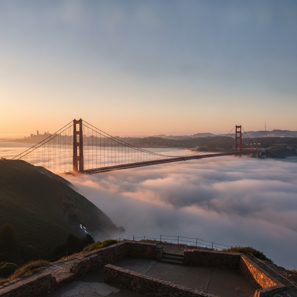
Battery Spencer, Marin Headlands — The Classic View
Battery Spencer (the former coastal artillery battery at the top of the Marin Headlands immediately north of the Golden Gate Bridge, accessible from the Conzelman Road viewpoints on the Marin side of the bridge): this is the location from which the most famous photographs of the Golden Gate Bridge are taken — the view looking south from the gun battery parapet provides the classic perspective showing the full length of the bridge, both towers, the cables in catenary sweep, and the city of San Francisco in the background; Battery Spencer was one of the US Army coastal defense batteries constructed in the late 19th century to protect San Francisco Bay from naval attack, and its concrete gun emplacements provide a platform elevated approximately 100 metres above the bridge deck; the viewpoint is particularly extraordinary in the fog conditions characteristic of San Francisco's summers, when the bridge emerges from and disappears into the low marine layer fog.
- 2
Golden Gate Bridge — Walking or Cycling Across
The Golden Gate Bridge (US Route 101, connecting San Francisco at the south end with Marin County at the north end, total length 2,737 metres including approach viaducts, main span 1,280 metres (the longest suspension bridge main span in the world from its completion in 1937 until 1964), deck height 67 metres above water at mid-span): the bridge is open to pedestrians and cyclists on the east sidewalk (adjacent to vehicle traffic) throughout the year; walking the bridge takes approximately 30-40 minutes one way (pedestrian access from both the San Francisco and Marin sides); the experience of walking across the bridge provides a completely different perspective from the automobile or viewpoint experience — the scale of the towers (227 metres above water), the enormous cables (approximately 27,572 individual wires bundled into cables 92 centimetres in diameter), the movement of the bridge deck in wind, and the views across the Bay toward Alcatraz, the Bay Bridge, and the hills of the East Bay are experienced at human scale; the bridge was painted in its distinctive 'International Orange' color (chosen by consulting architect Irving Morrow over the Navy's preference for black and yellow stripes — Morrow argued that the warm orange would harmonize with the California landscape and the Golden Gate's environment).
- 3
Fort Point — The Civil War Fort at the Bridge's Base
Fort Point (Marine Drive, directly under the south tower of the Golden Gate Bridge, National Historic Site): the brick fortification built by the US Army Corps of Engineers between 1853 and 1861 (the only American Civil War-era masonry fort on the West Coast) is one of the most dramatic and unusual historic sites in San Francisco — sitting directly under the south tower of the Golden Gate Bridge, with the massive steel cables and the bridge deck visible directly overhead; Fort Point was designed to mount approximately 126 cannon firing through three tiers of gun ports, but it was made obsolete by rifled artillery before it was ever completed or used in combat; the fort was preserved during the construction of the Golden Gate Bridge only because chief engineer Joseph Strauss insisted on constructing an arch to accommodate it (the only structural concession Strauss made to existing buildings during the bridge construction); the location provides the most dramatic close-up view of the bridge's south tower and the turbulent tidal waters of the Golden Gate at its narrowest point.
- 4
Baker Beach — The San Francisco Side View
Baker Beach (the mile-long sandy beach immediately south of the Presidio of San Francisco, approximately 2 kilometres south of the Golden Gate Bridge's south anchorage — the beach that provides the classic up-close view of the bridge from the California side, with the bridge visible at relatively close range to the north and the breakers of the Pacific visible to the west): Baker Beach is one of the few ocean beaches within the San Francisco city limits (as opposed to the generally calmer and more sheltered Bay beaches) and offers a distinctive experience of the conjunction of the city, the bay, and the Pacific Ocean that makes San Francisco's geography unique; the northern end of the beach, adjacent to the massive concrete anchorage of the bridge, is clothing-optional (a San Francisco institution since the 1970s); the beach is part of the Golden Gate National Recreation Area.
- 5
Presidio of San Francisco — Military History & National Park
The Presidio of San Francisco (the 1,500-acre former US Army base at the northern tip of the San Francisco Peninsula, adjacent to the Golden Gate Bridge — now a unit of the Golden Gate National Recreation Area managed by the National Park Service and the Presidio Trust): the Presidio is one of the oldest military installations in the American West, established as a Spanish colonial military garrison (presidio) in 1776 simultaneously with the establishment of Mission Dolores — the two institutions that effectively founded the city of San Francisco; the site was a Spanish colonial garrison until 1821, a Mexican military installation until 1846 (when it was occupied by US forces during the Mexican-American War), and a US Army base until 1994 (when it was transferred to the National Park Service as part of the creation of the Golden Gate National Recreation Area); the former military installation has been transformed into one of the most extraordinary urban national parks in the United States — 1,500 acres of forest, historic buildings, beaches, and viewpoints within the city limits.
- 6
Crissy Field — The Bay Shoreline & Wetland Restoration
Crissy Field (the tidal marsh and shoreline park along the south shore of the Golden Gate strait, between the Marina District and Fort Point, part of the Presidio): Crissy Field was formerly a US Army airfield (1919-1936) and subsequently a storage and maintenance area for the Army; in 2001 it was restored to its original tidal marsh environment by the Golden Gate National Parks Conservancy in a landmark urban ecological restoration project; the restored wetland provides essential habitat for migratory birds and has become one of the best urban wildlife observation sites in San Francisco; the shoreline path along Crissy Field provides the most accessible and most photogenic view of the Golden Gate Bridge from the California side — looking northwest from the beach or pathway, the bridge appears at close range with the Marin Headlands behind it and the city of San Francisco to the east.