Phuket Complete: Phang Nga Bay's James Bond Island, Sino-Portuguese Old Town & the Andaman Sea's Leopard Sharks
All sides of Phuket—Patong's Bangla Road nightlife strip where 30,000 people converge after midnight (and why half of visitors come, the other half avoid), Kata Noi's surf breaks and Rawai's local seafood market beyond the resort belt, Phang Nga Bay's karst needles by sea kayak through hidden hong lagoons and Ko Panyee's 360-family stilt village, the 2004 tsunami's 9.1 earthquake wave that struck at 09:00 and killed 250 on Phuket's beaches prompting the Indian Ocean warning system, Phuket Town's 19th-century Sino-Portuguese tin-mining shophouses funded by Hokkien families who once governed provinces, and Ko Racha and the Similan Islands' leopard sharks and manta rays.
- 1
Patong Beach & Phuket's Party Reputation
Patong—Phuket's largest and most developed beach, 3 km of sand on the west coast backed by a grid of streets containing Thailand's most concentrated nightlife district—defines the version of Phuket that most visitors know from reputation and most residents know from exhaustion. Bangla Road (the main entertainment strip, pedestrianised at night)—400 metres of bars, nightclubs, go-go bars, lady-boy cabaret shows, and street food—reaches its peak intensity between midnight and 4am when 10,000–30,000 people are simultaneously present. The beach itself: wide, clean sand, excellent swimming (outside the June–September monsoon season when red flags warn of rip currents), parasailing, banana boats, jet skis. The accommodation spectrum runs from budget guesthouses in the back streets to the Amari Phuket and Holiday Inn on the beachfront. Patong is the reason many visitors come to Phuket; it is also the reason many visitors avoid Phuket—the choice of whether to engage or avoid it determines the entire character of the trip.
- 2
Phuket's Beaches Beyond Patong – Kata, Karon & the South
Phuket's western coastline—protected from the Indian Ocean swell by its orientation and broken into coves by the forested hills running down the island's spine—offers a spectrum of beach experiences beyond Patong. Kata Noi and Kata Yai: two adjacent beaches separated by a rocky headland south of Patong—quieter (families, surfers during the May–October swell season), with a small town of restaurants and guesthouses. Karon: the longest beach on Phuket (4 km)—wide, less crowded than Patong, backed by a quieter town with international restaurants. Rawai and Nai Harn (the far south): the most authentically Thai corners of Phuket's developed coastline—Rawai's seafood market and local fishing community, Nai Harn's lake-backed beach (used by the Nai Harn yacht club) in a particularly sheltered bay. Phuket's east coast faces the sheltered Phang Nga Bay rather than the open sea—calmer waters, mangroves, long-tail boat access to the Phi Phi Islands and Phang Nga Bay's karst scenery.
- 3
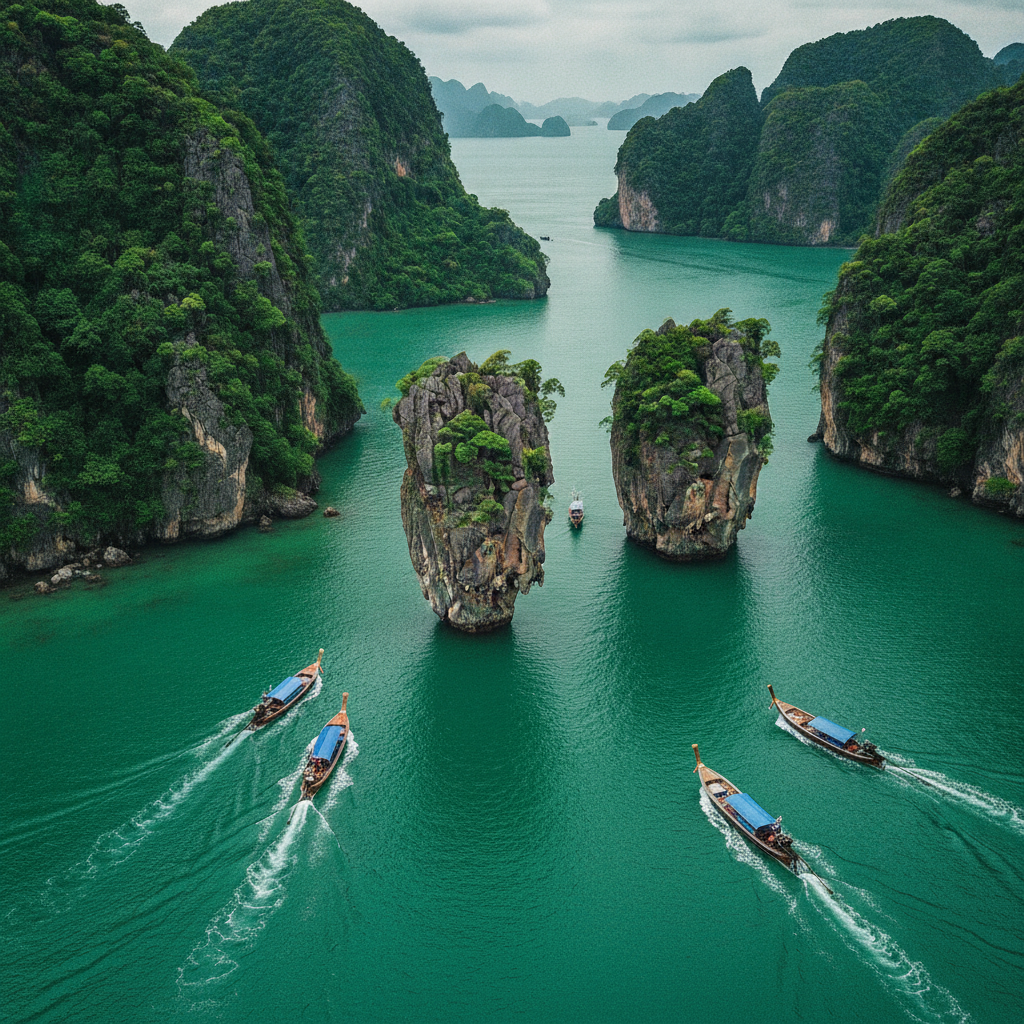
Phang Nga Bay – The Landscape of The Man with the Golden Gun
Phang Nga Bay—the sheltered body of water northeast of Phuket, enclosed between the mainland Phang Nga province and the island—contains approximately 40 karst limestone islands rising dramatically from shallow, bottle-green water, creating one of Southeast Asia's most recognisable marine landscapes. Ko Tapu—the 20-metre-high needle of limestone rising from the water, used as a villain's lair in the 1974 James Bond film The Man with the Golden Gun—is now universally called 'James Bond Island' and is the most photographed single object in southern Thailand. Ko Panyi (Koh Panyee)—a Muslim fishing village of 360 families built entirely on stilts above the water in the 18th century by a Javanese fishing family who were refused permission to live on the islands—is the most astonishing inhabited structure in the bay. Sea kayaking through the hong (hidden enclosed lagoons inside the karst islands, accessible only at low tide through low cave passages) is the most spectacular way to experience the bay's interior landscape.
- 4
The 2004 Tsunami – Phuket's Defining Trauma
The Indian Ocean tsunami of 26 December 2004—triggered by a 9.1 magnitude earthquake off the northern coast of Sumatra at 07:58 local time—struck Phuket's western coast with waves of 3–10 metres between 09:00 and 10:00, killing approximately 250 people on Phuket island (mostly at Patong, Kamala, and Khao Lak further north) and injuring thousands more. The total Indian Ocean death toll was 227,898 across 14 countries. Phuket's beach hotels and restaurants were devastated; the reconstruction over the following 3 years was largely complete by 2007 and created the modern beach strip infrastructure. The warning system failure (Thailand had no deep-ocean tsunami warning buoys in 2004; the Thai Meteorological Department's post-earthquake analysis took 90 minutes before any warning was issued) led directly to the establishment of the Indian Ocean Tsunami Warning System. A memorial at Ban Nam Khem (Phang Nga province, 2 hours north) marks the mainland site of highest casualties; Phuket's own memorial is at Patong beach.
- 5
Phuket Old Town – The Sino-Portuguese Heritage
Phuket Town (the island's capital city, on the east coast)—distinct from and often ignored in favour of the beach resort areas—contains the finest surviving concentration of Sino-Portuguese shophouse architecture in Thailand and one of the best in Southeast Asia. The architecture: 19th–early 20th century shophouses built by Chinese (primarily Hokkien) tin-mining entrepreneurs in a hybrid style blending Chinese shophouse typology (open fronts, internal courtyards) with Portuguese-colonial decorative elements (louvred shutters, pastel-coloured plaster facades, Roman-arch arcaded footpaths). The wealth behind these buildings came from Phuket's tin mining industry (the island's primary economic activity from the 16th century until the collapse of tin prices in the 1980s), dominated by Chinese immigrant families (the most powerful: the Na Ranong family, descendants of a 19th-century Hokkien miner who rose to become governor of Ranong province). Thalang Road and the adjacent streets contain the best-preserved shophouses; the Blue Elephant restaurant (in a former governor's mansion) and the Peranakan Museum anchor the heritage walk.
- 6
Phuket Diving & Marine Life – The Andaman Sea Underwater
The Andaman Sea surrounding Phuket—a body of water between the Malay Peninsula and the Andaman Islands that connects to the Bay of Bengal—contains some of the most diverse marine ecosystems in Southeast Asia. The primary diving sites: Ko Racha Yai (Racha Island, 30 km south—clearest water in the Phuket area, coral gardens at 18–30 metres, frequent manta ray and whale shark sightings April–May); Shark Point (Hin Musang—a submerged seamount, leopard sharks resting on the bottom in groups); Anemone Reef; the King Cruiser Wreck (a car ferry that sank in 1997, now colonised by schooling fish and soft coral); and the Similan Islands (100 km northwest—a 9-island national marine park with the clearest water and healthiest coral in the Andaman Sea, accessible on liveaboard dive trips). Visibility: 15–40 metres in the dry season (November–April); reduced during the monsoon. The coral bleaching events of 2010 and 2016 (driven by elevated ocean temperatures) caused significant damage to the Andaman Sea reef systems; recovery has been partial.