The Cat Nobody Knew Existed Until 1965, the Westernmost Japanese Island Where You Can See Taiwan & the 1,800 Tonnes of Unexploded Ordnance Still in Okinawan Soil
The Iriomote cat's 1965 discovery as one of the 20th century's most significant mammal finds (now 100–120 individuals remain); the Yonaguni westernmost Japan point 110 km from Taiwan; the Yonaguni Monument's unresolved academic debate with peer-reviewed papers on both sides; the 2,000 unexploded shells recovered annually in Okinawan construction sites; the Henoko protest camp as the longest-running sit-in protest in postwar Japan; and the Peach Aviation ¥3,990 sale fare as the cheapest domestic air ticket in Japan per km.
- 1
Miyako Island – Okinawa's Flat Coral Paradise
Miyako Island (宮古島—the largest island of the Miyako Archipelago, located 300 km southwest of the Okinawa main island and 200 km northeast of Ishigaki in the Yaeyama Islands—an island of 50,000 residents and a flat landscape almost entirely surrounded by shallow coral shelves): the most fashionable beach destination in the Ryukyu Island chain for Japanese domestic visitors since the 2010s and the fastest-growing tourist destination in Okinawa Prefecture. The Miyako topography (the island's flat limestone plateau (maximum elevation 114 metres—the flattest island terrain of any significant island in Japan): the coral limestone base creates the characteristic Miyako water clarity—the freshwater percolates through limestone and emerges at the shoreline in a way that produces exceptionally clear nearshore water (the 'Miyako Blue')). The Yonaha Mae-hama Beach (the western shore beach of Miyako Island—a 7-km-long stretch of white coral sand beach with consistent shallow water across the entire width; rated among the top 5 beaches in Japan in virtually every domestic travel survey published since 2010): the most accessible high-quality beach in the Okinawa outer islands (the beach is immediately adjacent to the Miyako Airport road). The bridges (the Kurima Bridge (1,690 metres—connecting Miyako Island to the small Kurima Island) and the Ikema Bridge (1,425 metres—connecting to Ikema Island to the north): the 3 bridges connecting the Miyako island group (Miyako, Kurima, Ikema, and Irabu) make the island cluster drivable by rental car—the only outer island cluster in Okinawa that is fully connected by road): the Irabu Bridge (3,540 metres—the longest toll-free bridge in Japan, opened 2015).
- 2
Ishigaki Island – The Yaeyama Gateway
Ishigaki Island (石垣島—the main island of the Yaeyama Archipelago, 450 km southwest of Naha and 270 km east of Taiwan): the transportation hub of the most remote inhabited island chain under Japanese sovereignty and the last large island before the Yonaguni western extreme (110 km from Taiwan). The Ishigaki landscape: the mountainous terrain (unlike the flat Miyako—Ishigaki has actual mountain peaks up to 526 metres (Mount Omoto, the highest peak in Okinawa Prefecture)) covered in subtropical forest in the north and the most extensive mangrove habitat in Japan (the Fukido River mangrove kayaking—the 2-km mangrove estuary that is the most accessible mangrove environment in Japan, navigable by rented kayak at any tide). The Kabira Bay (the protected bay on the northwest coast of Ishigaki—the shallow, clear bay with sand-bar islands covered in dense subtropical forest and the pearl cultivation frames visible through the transparent water; the glass-bottom boat tour (20 min; ¥1,050) is the most efficient way to see the pearl farm operation without entering the swimming-restricted water): the most photographed single location in the Yaeyama Islands. The Ishigaki black sugar (Okinawan kuro-zato—Ishigaki Island is the largest producer of black sugar (unrefined cane sugar) in Japan: the sugar cane fields cover approximately 30% of the flat agricultural land south and east of Ishigaki City; the Ishigaki black sugar (pressed sugar cane evaporated to a dark, mineral-rich solid) is the primary Ishigaki food souvenir): the black sugar ice cream, black sugar bun, and black sugar pancakes are the most distinctive Ishigaki local food format.
- 3
Yonaguni Island – Japan's Westernmost Point
Yonaguni Island (与那国島—the westernmost island of Japan, 1,600 km west of Tokyo, 110 km from the eastern coast of Taiwan, and 25 km from the 100-mile limit of the Taiwan Strait): the most geographically extreme Japanese island and the one with the most intense sense of being at the edge of Japan. The Yonaguni geography (a small triangular island of 28.9 km² with steep coastal cliffs on the north and a flat southern coastal plateau): the western cape of Yonaguni (Irizaki—the westernmost geographical point of Japan; the stone marker and lighthouse at Irizaki is the point from which Taiwan is visible on clear days at 110 km distance): the experience of standing at the western extreme of Japan and looking toward Taiwan across the Taiwan Strait. The Yonaguni Monument (the underwater formation at 25–27 metres off the south coast of Yonaguni—the stepped terrace structure discovered in 1986 by dive guide Kihachiro Aratake; the formation has been interpreted alternately as a natural erosion product of the local Yonaguni sandstone's flat-bedding pattern and as an artificial construction of uncertain age (some researchers argue for 8,000–12,000 BCE construction, which would make it one of the oldest stone constructions in the world)): the academic debate (the Ryukyu University marine geologist Masaaki Kimura argues for construction; the Boston University geologist Robert Schoch argues for natural formation): the debate remains unresolved with peer-reviewed publications supporting both positions. The Yonaguni Doctor Fish (the spa and hot spring on Yonaguni where the Garra rufa fish (the cleaner fish that feeds on dead skin) are used in foot-bath therapy—the most eccentric wellness offering in the westernmost point of Japan).
- 4
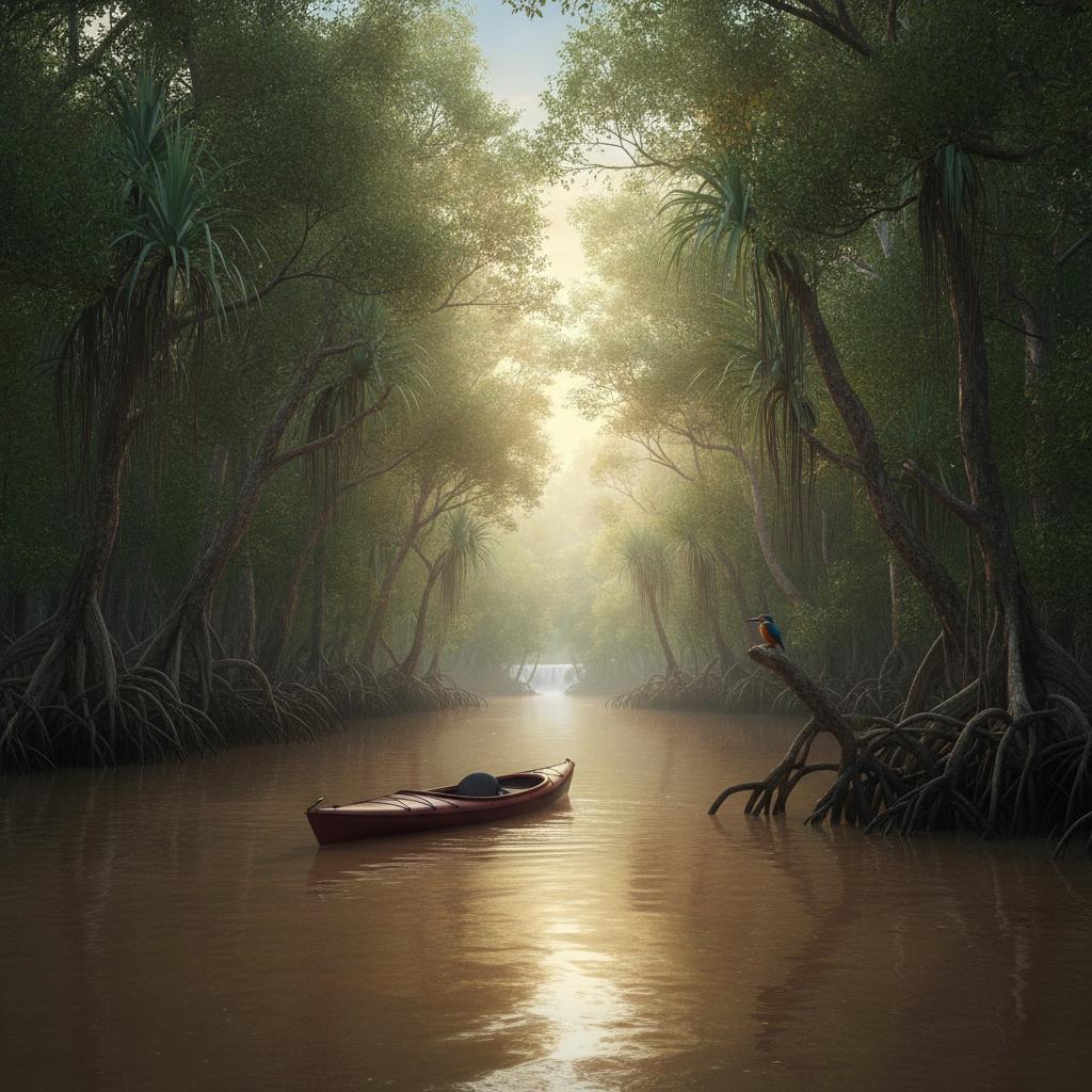
Iriomote Island – The Wild Heart of Okinawa
Iriomote Island (西表島—the largest island of the Yaeyama Archipelago (294 km²), 40 minutes by ferry from Ishigaki): the most biologically diverse island in Japan and the one with the most extensive wilderness relative to its land area (the island is 90% subtropical jungle—the largest subtropical forest in Japan). The Iriomote wild cat (Prionailurus iriomotensis—the Iriomote cat, endemic to Iriomote Island and classified as critically endangered by the IUCN with an estimated population of 100–120 individuals): the rarest wild cat in Asia and the cat whose discovery in 1965 by mammologist Yukio Togawa was one of the most significant mammal discoveries of the 20th century (the cat had been unknown to science before 1965 and was initially classified as a new genus before genetic analysis confirmed it as a distinct species of the leopard cat lineage). The Urauchi River kayaking (the Urauchi River—the longest river in Okinawa Prefecture, 40 km in length, navigable by rented kayak from Iriomote's northern coast for the first 15 km): the most complete subtropical river journey available in Japan (the river passes through gallery forest of mangrove, Pandanus palms, and Cycas revoluta tree ferns—the prehistoric plant assemblage of the Iriomote forest). The Marudo Waterfall (at the end of the Urauchi River kayak route—the 18-metre waterfall in the interior of the Iriomote jungle): the most remote waterfall in Okinawa and the one requiring the most physical effort to reach. The Iriomote access and accommodation: the only accommodation option is the small guesthouses and simple resort hotels on the coastal fringe (the interior of the island has no human settlement).
- 5
Okinawa's World War 2 Legacy Today
The ongoing legacy of the Battle of Okinawa in contemporary Okinawan society (the ways in which the 1945 battle continues to shape daily life in Okinawa in 2026—the US base presence, the UXO (unexploded ordnance) clearance operations, the memorial culture, and the political tension): the dimension of Okinawa that most distinguishes it from any other Japanese destination. The UXO clearance (the unexploded ordnance disposal operations that continue in Okinawa: approximately 2,000 shells, bombs, and grenades are recovered annually in construction excavations across the island; the total estimated unexploded ordnance remaining in Okinawan soil is 1,800 tonnes (as of 2020 Ministry of Defense estimates); every major construction project in southern Okinawa requires an ordnance clearance survey before groundbreaking): the most direct ongoing physical legacy of the 1945 battle. The anti-base movement (the political movement in Okinawa that seeks the return of US military land—the most consistently present civil society campaign in postwar Japanese politics, with protest camps at the Henoko construction site (the Marine Corps Air Station Futenma relocation site) that have been maintained without interruption since 2014): the Henoko protest camp as the longest-running sit-in protest in postwar Japan. The hibaku (the civilians who survived the Battle of Okinawa—the living survivors of the battle (in 2026, the youngest survivors of the 1945 battle are in their 80s; the Himeyuri Peace Museum's oral history programme has recorded 136 testimonies before death silenced the witnesses): the race to record surviving testimony before the last Okinawan war generation dies. The Okinawa reversion anniversary (15 May—the anniversary of the 1972 return of Okinawa to Japanese sovereignty after 27 years of US administration): the annual event that provokes the most politically charged public debate in Okinawa about the terms of the reversion and the continued US base presence.
- 6
Planning a Trip to Okinawa – Complete Logistics
The complete Okinawa trip planning framework (the practical logistics for a visitor coming from Tokyo, Osaka, or internationally, covering budget, timing, internal transport, and accommodation strategy): the framework that produces the least friction and most value per travel day. The flights (Tokyo to Naha: ANA and JAL, 2h15m, ¥18,000–40,000 on full-service; Peach and Jetstar from Tokyo Narita and Osaka Kansai, ¥5,000–15,000 if booked 2–3 months ahead): the LCC discount window (the Peach Aviation sale periods in January and August that offer Tokyo–Naha fares as low as ¥3,990 one way—the cheapest air ticket in the domestic Japanese market per km). The timing (the optimal months—May, June (before the rainy season peak), late September, October: the shoulder periods that avoid the summer crowds (July–August) and the typhoon risk (August–October)): the June rainy season ('tsuyu'—Okinawa enters its rainy season in mid-May and exits it in mid-June, approximately 6 weeks earlier than the mainland: in late June, Okinawa is often sunny while mainland Japan is still in rainy season). The budget (the realistic daily budget per person: ¥15,000–20,000 for the main island (hotel + food + transport without rental car); ¥25,000–35,000 with rental car; ¥30,000–50,000 for the Yaeyama Islands where accommodation and food costs are higher). The inter-island transport (domestic air (ANA, JAL, ORCA Air) from Naha to Ishigaki (55 min, ¥8,000–20,000) or Miyako (40 min, ¥6,000–15,000): the only practical route to the outer islands for visitors with less than 2 weeks). The accommodation strategy: beach resort for the summer season (Onna Village); business hotel in Naha for the historical/cultural focus (the ¥10,000–15,000 range on the monorail route); guesthouse on the outer islands (¥6,000–10,000 per person including dinner and breakfast in the Yaeyama guesthouse format).