Monterrey Mountains and Nature: Grutas de Garcia Limestone Caves, Cola de Caballo Waterfall, Chipinque Ecological Park and the Sierra Madre Canyon System That Makes This the Most Dramatically Situated Industrial City in Mexico
Monterrey sits inside a natural amphitheater formed by the Sierra Madre Oriental mountains that rise abruptly from the Nuevo Leon plain to elevations above 2,500 metres within 30 kilometres of the city center, creating a landscape configuration where a steel mill worker in 1930 could look up from the foundry floor and see mountain peaks, and where a contemporary regiomontano with a car can drive from urban traffic to pine forest hiking in less than an hour. The Parque Nacional Cumbres de Monterrey, established in 1939 as one of the earliest protected natural areas in Mexico, covers 177,000 hectares of the Sierra Madre Oriental ranges surrounding the city, containing old-growth pine and oak forest, wetlands fed by the mountain springs, and a network of hiking trails connecting the Cola de Caballo waterfall, the Grutas de Garcia limestone cave system, and the Cumbres plateau viewpoints. The Chipinque Ecological Park, a 1,800-hectare protected area on the slopes of the Sierra Madre immediately south of the San Pedro Garza Garcia municipality that can be reached from the wealthiest neighborhoods in Mexico in a 15-minute drive, provides hiking and mountain biking trails through oak and pine forest at elevations ranging from 800 to 2,200 metres, serving as the primary outdoor recreation destination for the Monterrey middle and upper class. The Huasteca Canyon, a slot canyon cut through the limestone of the Sierra Madre 25 kilometres west of the city center, is the most dramatic near-urban geological feature in northern Mexico.
- 1
Grutas de Garcia Limestone Cave System
The Grutas de Garcia, a limestone cave system 45 kilometres northwest of Monterrey at 1,000 metres elevation in the Cerro del Fraile, is one of the largest and most accessible cave systems in Mexico, with 16 rooms and chambers extending 2 kilometres into the mountain and containing stalactites, stalagmites, and flowstone formations accumulated over millions of years of limestone dissolution by underground water. The caves are reached from the village of Villa de Garcia by a cable car, the only cave access by cable car in Mexico, that rises 350 metres to the cave entrance, providing a panoramic view of the Nuevo Leon plain and the Monterrey metropolitan area visible to the southeast. The cave system was first described by Europeans in 1843 and developed for tourism in the 1930s with electric lighting and concrete walkways. The geological history of the cave formation spans approximately 50 to 60 million years, with the oldest formations dating to the Eocene epoch. The fossil marine organisms preserved in the limestone walls of the Grutas de Garcia, including ancient coral, mollusks, and echinoderm fragments, document the shallow tropical sea that covered the Nuevo Leon region 80 to 100 million years ago during the Cretaceous period, when the Sierra Madre Oriental mountains had not yet formed and the continental plate was at a different latitude and elevation. The caves are the primary family day-trip destination from Monterrey and receive approximately 300,000 visitors annually.
- 2
Cola de Caballo Waterfall and National Park
The Cola de Caballo, the horsetail waterfall in the Parque Nacional Cumbres de Monterrey 35 kilometres south of Monterrey in the municipality of Santiago, drops 25 metres over a limestone cliff into a pool surrounded by subtropical mountain forest, and is the most visited natural attraction in Nuevo Leon with access via a 2-kilometre walking trail through the river canyon from the parking area in the village of El Cercado. The national park surrounding the waterfall was established in 1939 and covers terrain ranging from the subtropical dry forest of the lower canyons to the temperate pine and oak forest of the higher elevations, with the canyon environments hosting a diverse bird population including military macaws, emerald toucanets, and several endemic species of the Sierra Madre Oriental. The river canyon below the Cola de Caballo contains a series of swimming holes and smaller cascades accessible by hiking downstream from the main waterfall, and the canyon walls of volcanic and limestone rock provide sport climbing routes that have been developed since the 1990s by a Monterrey climbing community that is among the most active in Mexico. The village of Santiago, at the entrance to the national park, produces the most highly regarded queso blanco fresh cheese and dulce de leche caramel of Nuevo Leon, sold at roadside stands and village market stalls. The combination of waterfall, canyon, climbing, and artisanal food makes the Cola de Caballo area the most complete natural tourism destination within day-trip distance of Monterrey.
- 3
Chipinque Ecological Park Urban Hiking
The Chipinque Ecological Park, 1,800 hectares of protected pine and oak forest on the slopes of the Sierra de las Mitras immediately above the San Pedro Garza Garcia municipality, the wealthiest municipality in Mexico by per capita income, serves as the backyard wilderness area for the Monterrey executive and professional class, with trail access from a parking area at 900 metres elevation and routes climbing through dense forest to viewpoints at 2,200 metres from which the entire Monterrey metropolitan area and the surrounding mountain panorama are visible. The park, privately managed by a nonprofit foundation funded by the San Pedro Garza Garcia municipality and corporate sponsors, charges an entry fee and maintains a network of 60 kilometres of marked trails ranging from easy family walks to strenuous ascents requiring 4 to 5 hours. The wildlife of Chipinque, which borders the Parque Nacional Cumbres de Monterrey, includes white-tailed deer, coyotes, bobcats, and a significant population of Mexican jays and other highland bird species. The park is the primary mountain biking destination in Monterrey, with trails classified for difficulty and maintained by the park foundation. The adjacency of Chipinque to the wealthy residential neighborhoods of San Pedro Garza Garcia, which include some of the most expensive housing in Mexico, creates the distinctive Monterrey landscape contrast of luxury residential areas giving direct access to wilderness hiking that no other major Mexican city replicates.
- 4
Cañon de la Huasteca Slot Canyon
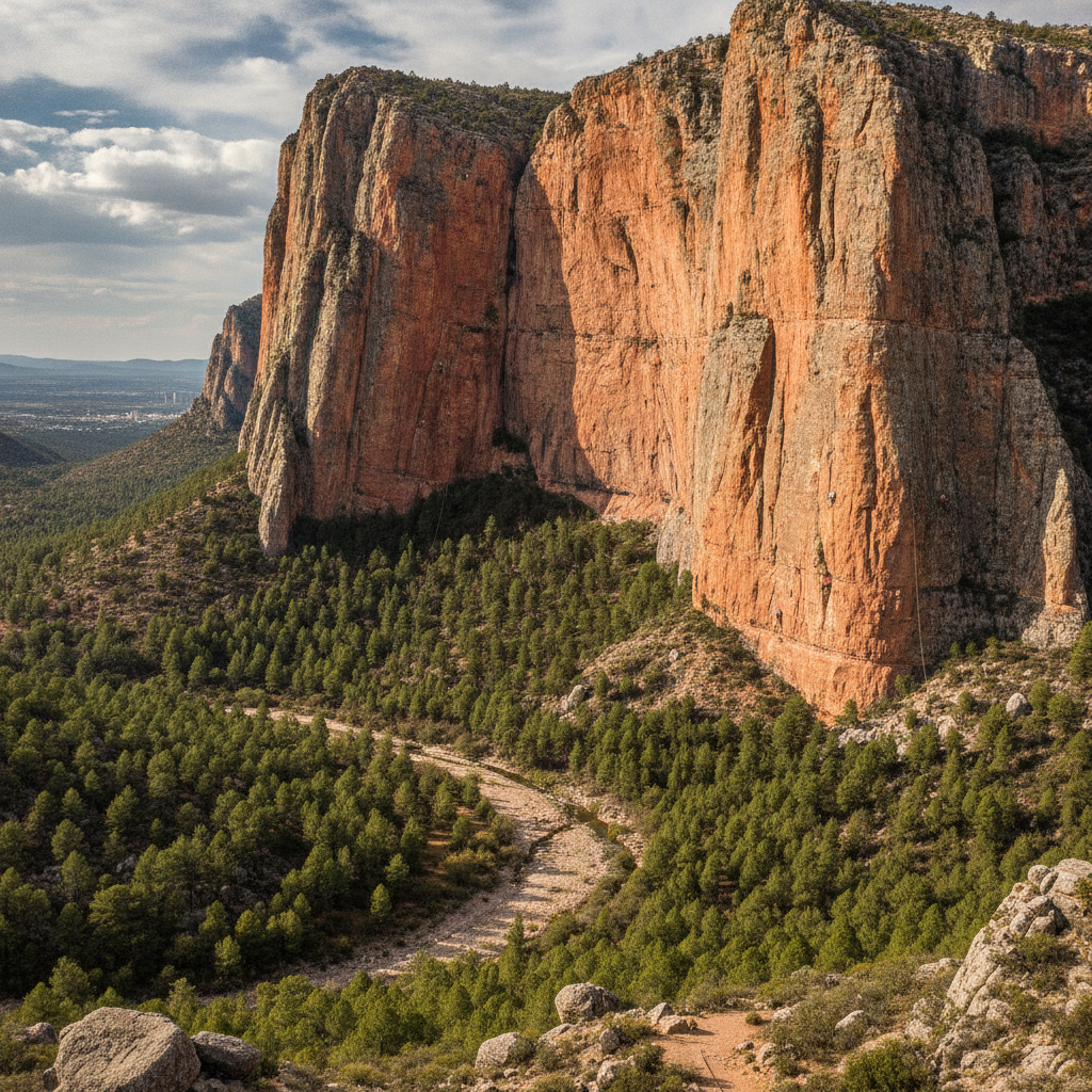
The Canon de la Huasteca, a slot canyon carved by the Santa Catarina River through the limestone of the Sierra Madre Oriental 25 kilometres west of the Monterrey city center in the municipality of Santa Catarina, contains walls rising 300 metres from the canyon floor with the geometry of red and grey limestone cliffs that have made it the primary rock climbing destination in northern Mexico and one of the most significant limestone climbing areas in the country. The canyon is accessible by road from Monterrey in 30 to 40 minutes and the canyon floor is a public park where families picnic at the base of the cliffs while climbers on the walls above them work routes ranging from beginner to extreme difficulty. The geological character of the Huasteca canyon, with its vertical and overhanging limestone walls, pinnacles, and caves, was formed by the same tectonic uplift that created the Sierra Madre Oriental during the Laramide orogeny 40 to 65 million years ago, when the compression of the continental plate buckled and folded the sedimentary layers laid down in the ancient Cretaceous sea into the mountain ranges visible today. The hiking trail through the canyon floor provides access to a series of ecological zones from the dry scrub of the canyon entrance to the riparian woodland of the permanent stream at the canyon bottom. The Huasteca is the most photographed natural feature in the Monterrey metropolitan area and the landscape most associated with the rugged outdoor identity that regiomontanos cultivate.
- 5
Mountain Culture and Regiomontano Identity
The outdoor and mountain culture of Monterrey, expressed in the popularity of hiking, rock climbing, mountain biking, and trail running among the city's professional class, is inseparable from the regiomontano identity that positions the city's residents as more physically vigorous, more entrepreneurial, and more northern-Mexico-hard than residents of the warmer and more comfortable cities of central and southern Mexico. The Monterrey outdoor culture has produced a competitive trail running scene with events including the Ultramaratón de los Cañones, a 50-kilometre trail race through the canyon systems of the Sierra Madre, and the GORE-TEX Ultratrail Cerro de la Silla, a race ascending the iconic saddle-shaped mountain. The rock climbing community of Monterrey, one of the oldest organized climbing groups in Mexico, established the Huasteca and Potrero Chico as internationally recognized climbing destinations and has produced several elite climbers including figures who have made first ascents in Patagonia and the Alaska Range. The Potrero Chico canyon, 50 kilometres north of Monterrey in the municipality of Hidalgo, is considered one of the premier multi-pitch limestone climbing destinations in North America, with big wall routes rising over 700 metres and attracting climbers from the United States and internationally during the October through March climbing season. The outdoor recreation economy in the Monterrey region represents a significant tourism sector distinct from the industrial and business tourism that dominates the city.
- 6
Sierra Madre Oriental Geology and Ecology
The Sierra Madre Oriental, the eastern Sierra Madre mountain range forming the geological backbone of the Nuevo Leon landscape and surrounding Monterrey on the north, west, and south, consists of folded and faulted limestone and shale layers deposited in the ancient Cretaceous sea and subsequently compressed and uplifted by the Laramide orogeny, creating the characteristic ridge and valley topography of parallel mountain ranges separated by intermontane basins that is visible in the mountain panorama from any high point in Monterrey. The ecological zones of the Sierra Madre Oriental in the Nuevo Leon section span from the semi-desert scrub of the plains and lower slopes, dominated by lechuguilla agave, yucca, and acacia, through the subtropical thornscrub of the canyon environments, to the temperate pine and oak forest of the upper elevations where Douglas fir reaches its southernmost natural distribution in North America. The Sierra Madre Oriental is one of two mountain ranges in Mexico recognized as a biodiversity hotspot for endemic bird species, with the Sierra Madre Oriental endemic bird species numbering approximately 20, including the Sierra Madre sparrow and the Worthen sparrow. The Cerro el Potosi in southern Nuevo Leon, at 3,700 metres the highest peak in northeastern Mexico, supports an alpine ecosystem above the tree line including frost-tolerant grasses and alpine wildflower meadows that are biologically isolated from similar habitats hundreds of kilometres to the north and south, creating evolutionary conditions for local plant and insect endemism.
Walk this route with audio
Stories play automatically as you reach each stop — no tapping needed.
More in Monterrey
Monterrey Colonial History and Nuevo Leon Founding: The Crypto-Jewish Settlers of Luis de Carvajal the Younger, the Failed First Settlements and the 1596 Establishment That Finally Survived

Monterrey Food Culture: Cabrito Roasted Kid Goat, Carne Asada the Northern Mexican Grill Tradition, Pan de Polvo Cookies and the Machaca Dried Beef That Defines the Northern Mexican Ranching Table
Monterrey Water Crisis, Urban Heat and the Environmental Cost of Industrial Growth in the Semi-Arid Nuevo Leon Valley Where Summer Temperatures Hit 45 Celsius and the Metropolitan Area Ran Out of Tap Water in 2022

Monterrey Sport and Stadium Culture: Tigres and Rayados Football Rivalry, the PPG Paints Arena Boxing Tradition and the Regiomontano Sports Identity That Turns Two Football Clubs Into a Proxy for Class Division

Monterrey Music Identity: Norteño and Grupero Accordion Music from the Nuevo Leon Border Corridor That Became the Soundtrack of the Mexican Diaspora and the Cultural Background of 35 Million Mexican Americans