Everglades & Biscayne National Park — The Wilderness at Miami's Door
Miami is unique among major American cities in its proximity to two extraordinary national parks: Everglades National Park (the largest subtropical wilderness in the United States, UNESCO World Heritage and International Biosphere Reserve) and Biscayne National Park (the only national park in the US where the majority of the park's area is underwater — the coral reefs, mangrove forests, and shallow bays of southern Biscayne Bay).
- 1
Everglades National Park — The River of Grass
Everglades National Park (the 610,000-hectare national park at the southern tip of the Florida Peninsula, 50 km southwest of Miami — the largest subtropical wilderness in North America, UNESCO World Heritage since 1979, International Biosphere Reserve since 1976, and Wetland of International Importance since 1987 — the only ecosystem in the world to hold all three UNESCO/Ramsar designations): the Everglades (the 'River of Grass' as described by the conservationist Marjory Stoneman Douglas (1890-1998) in her foundational 1947 work — the vast sheet of slow-moving fresh water (the 'Pa-hay-okee' in Miccosukee) flowing south from Lake Okeechobee (the largest freshwater lake in Florida (1,900 km²)) across the flat limestone substrate (the 'Miami Oolite' limestone formation) of the Florida Peninsula to Florida Bay (the shallow estuary at the southern tip of Florida where the freshwater meets the salt water of the Gulf of Mexico and the Florida Straits) at a rate of approximately 100 metres per day) is one of the most biologically diverse ecosystems in the world, home to 36 species of threatened or endangered animals including: the American alligator (Alligator mississippiensis — approximately 1.3 million individuals in Florida), the American crocodile (Crocodylus acutus — the only place in the world where alligators and crocodiles coexist), the Florida panther (Puma concolor coryi — approximately 120-230 individuals, the most critically endangered large cat in North America), the West Indian manatee (Trichechus manatus — approximately 6,620 individuals, 90% of the US population), and the roseate spoonbill (Platalea ajaja — the spectacularly pink wading bird, the most photographed bird in the Everglades).
- 2
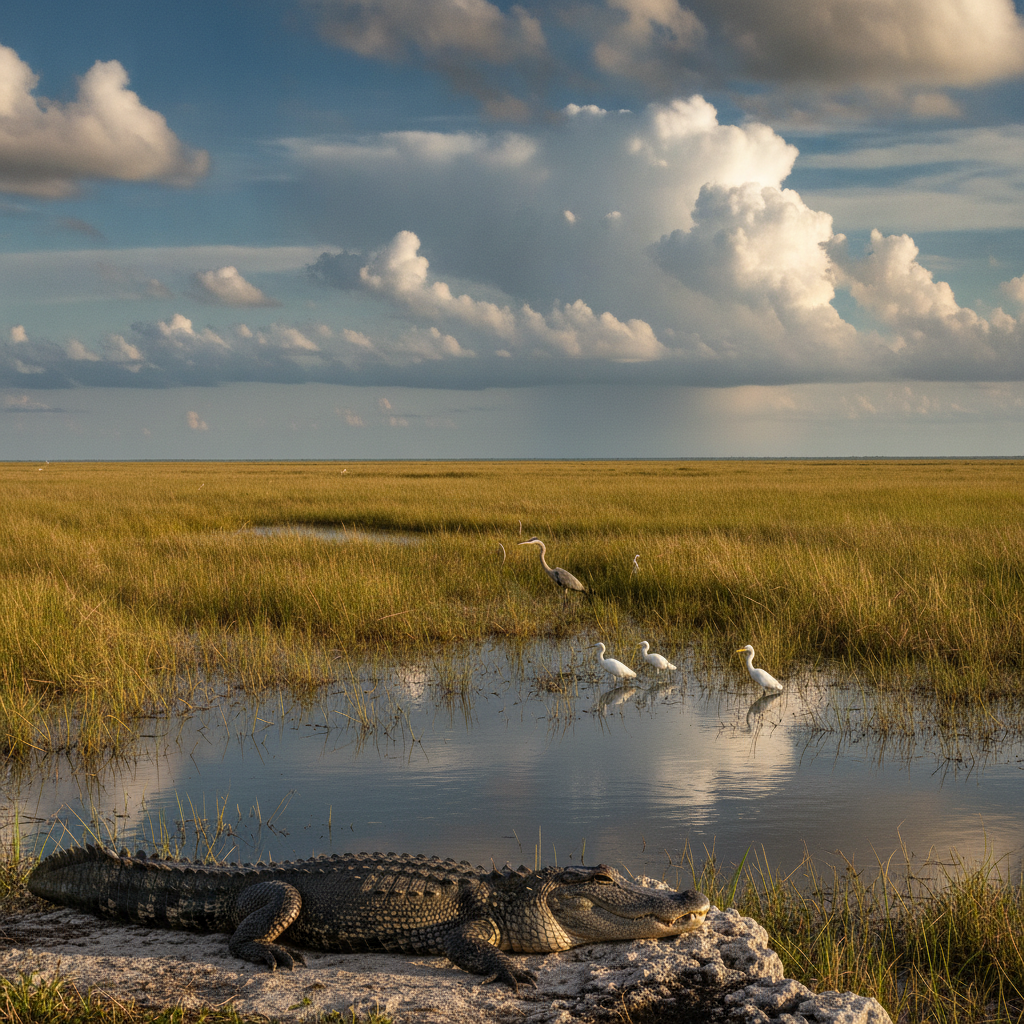
Anhinga Trail & Royal Palm Area — Wildlife at Close Range
Anhinga Trail (the 0.8 km boardwalk and paved trail loop through the Taylor Slough area of the Royal Palm Hammock in Everglades National Park, 8 km from the main park entrance on Route 9336 — the most wildlife-rich short trail in the United States): the trail (named for the anhinga (Anhinga anhinga — the 'snakebird', the water bird that lacks the waterproofing oil in its feathers that most water birds possess, so that after diving for fish (the anhinga catches fish by swimming underwater and impaling them with its sharp beak rather than grabbing them) it must dry its wings by standing with wings spread in the sun — the most commonly observed large bird on the trail, and the bird whose distinctive wing-spreading pose is the most photographed wildlife behaviour in the Everglades) passes within metres of sunbathing alligators (American alligators are so habituated to human presence on the Anhinga Trail that they may be within touching distance (the park strictly prohibits approaching within 15 feet (4.6 metres)), the giant turtles (the Florida red-bellied cooter (Pseudemys nelsoni) and the Florida softshell turtle (Apalone ferox) frequently visible on submerged logs), and the colonial waterbird nesting areas (the great blue heron (Ardea herodias), the great egret (Ardea alba), the little blue heron (Egretta caerulea), and the tricolored heron (Egretta tricolor) nest in the trees directly above the trail in the winter dry season (November-April)): the Royal Palm Hammock (the dense subtropical hardwood forest around the Royal Palm Area) is the finest example of the hardwood hammock (hàmac — the dense, elevated island of tropical and subtropical trees rising above the surrounding sawgrass prairie) ecosystem in the park.
- 3
Flamingo & Florida Bay — The Southern Wilderness
Flamingo (the small visitor centre and marina at the southern end of the main park road in Everglades National Park, 60 km from the park entrance — the most remote and least visited major destination within the park, and the most biologically rich): the approach drive from the park entrance to Flamingo along the 60 km main park road (the only paved road through the interior of the park) passes through the full range of Everglades ecosystems: the sawgrass prairie (the dominant landscape, the flat expanse of Cladium jamaicense sawgrass (so named for the serrated edges of the leaf blades that can cut through clothing) extending to the horizon, punctuated by 'tree islands' (the slightly elevated hammocks of willow and bay trees that rise from the sawgrass)); the Florida Bay (the 2,200 km² shallow estuary south of the Florida mainland that separates the Florida Keys from the Everglades) is the wintering ground for the largest concentration of wading birds in North America (the 'Christmas Bird Counts' in Florida Bay consistently record the largest single-count totals of bird species in North America); the Flamingo area is also the entry point for the Wilderness Waterway (the 99-mile (159 km) canoe and kayak route through the mangrove wilderness of the southwestern Everglades — the longest paddling trail in the southeastern United States).
- 4
Airboat Tours — Experiencing the Everglades the Florida Way
Airboat tours (the flat-bottomed boats propelled by an aircraft-style propeller mounted above the stern, capable of travelling across the shallow sawgrass prairie at speeds of up to 56 km/h (35 mph) — the primary method of accessing the interior of the Everglades outside the main park road): the airboat tour (the most popular tourist activity in the Everglades, offered by numerous commercial operators on the northern and eastern fringes of the Everglades (particularly along US-41 (the Tamiami Trail — the historic cross-Florida highway built 1928, cutting across the northern Everglades from Miami to Naples)) is simultaneously the most efficient way to see large areas of sawgrass prairie and the most controversial (the high-speed airboats are loud and can cause habitat disturbance, particularly in bird nesting areas — they are banned within the boundaries of Everglades National Park itself, but permitted on the Miccosukee Tribe lands north of the park)); the best airboat operators (Everglades Safari Park, Coopertown Airboat Tours (the oldest airboat tour operator in the Everglades, operating since 1945), and the Miccosukee Indian Village airboat tours (the tours operated by the Miccosukee Tribe (the Miccosukee (Mikisúkî) people, the primary Native American group of the Everglades, who have lived in the sawgrass prairie for approximately 150 years since the Second and Third Seminole Wars drove the surviving Seminole into the Everglades — the only Native American group in US history never to sign a peace treaty with the United States government)) on US-41) offer the most authentic Everglades experience outside the national park.
- 5
Key Biscayne & Biscayne National Park — Coral Reefs & Mangroves
Biscayne National Park (the 172,971-acre (70,000-hectare) national park in southern Biscayne Bay, 14 km south of Miami — the largest marine national park in the continental United States and one of the least visited national parks in the system, as 95% of the park is underwater, requiring a boat to access the interior): the park protects the northernmost section of the Florida Reef (the only living coral barrier reef in the continental United States, and the third largest in the world after the Great Barrier Reef in Australia and the Mesoamerican Reef in Mexico/Belize/Honduras/Guatemala — the reef stretching 360 km (224 miles) from Miami to the Dry Tortugas National Park); the main accessible destinations within the park are: Elliott Key (the largest barrier island in the park, accessible by park boat tour or private boat (56 km/h from the Dante Fascell Visitor Center in Homestead), with a freshwater well, campground, and hiking trail through the hardwood hammock), Adams Key (the smaller island with a day-use picnic area), and the reef snorkelling and SCUBA diving sites (the John Pennekamp Coral Reef State Park in Key Largo is the most accessible reef diving in the region); Key Biscayne (the upscale residential barrier island 6 km east of downtown Miami, connected by the Rickenbacker Causeway) is the Miami neighbourhood with the finest natural environment — Crandon Park (the 2.5 km public beach and nature area on the north part of the island) and Bill Baggs Cape Florida State Park (the 1.6 km natural beach on the south tip of the island, with the Cape Florida Lighthouse (1825 — the oldest standing structure in Miami-Dade County)) are the best beaches in the Miami area.
- 6
Miami's Climate & the Future of a Sea-Level City
Miami's climate and geography (the subtropical climate of Miami (USDA hardiness zone 11a — the warmest zone of any major city in the continental United States (mean annual temperature 25°C (77°F), monthly mean temperatures ranging from 21°C (70°F) in January to 29°C (84°F) in July, with year-round sunshine (average 3,000 hours of sunshine per year — the sunniest major city in the eastern United States) and the highest average humidity of any major American city): the climate that makes Miami the playground of America (the guaranteed winter warmth, the outdoor lifestyle, the beach culture) is also the city's most serious vulnerability; Miami is the American city most at risk from climate change, due to its extraordinary flatness (the average elevation of Miami-Dade County is approximately 1.8 metres (6 feet) above sea level — approximately 1/3 of the county is below 1 metre above sea level), the porousness of the underlying Miami oolite limestone (which allows seawater to percolate upward through the rock regardless of the height of any sea wall — a characteristic that makes traditional coastal flood defences (sea walls, levees) largely ineffective in Miami), and the increasing frequency and intensity of hurricanes (the most recent major storms to affect Miami being Hurricane Irma (2017, Category 4 at landfall in Florida) and Hurricane Ian (2022, Category 4, though tracking further north)): the Miami Beach sea-level rise adaptation programme ('Miami Forever' — the $400 million programme of pump stations, raised roads, and elevated public spaces begun in 2015) is the largest and most ambitious climate adaptation programme of any American city.