Venice Beach, Santa Monica Pier & the LA Waterfront
The 22-mile Los Angeles coastline from Palos Verdes to Malibu is one of the defining landscapes of American popular culture. This route focuses on its most iconic and accessible section: Venice Beach (the countercultural carnival boardwalk), the Santa Monica Pier (the official end of Route 66), and the neighborhoods — Venice, Santa Monica, Ocean Park — that have attracted artists, bohemians, and visionaries since the early 20th century.
- 1
Abbot Kinney Boulevard & Venice Arts District
Abbot Kinney Boulevard — named for the tobacco magnate Abbott Kinney (1861-1920) who built the planned resort community of 'Venice of America' (with 16 miles of canals, gondoliers imported from Italy, and a colonnade modeled on St. Mark's Square) on these salt marshes in 1905 — is now the most fashionable shopping and restaurant street in Los Angeles: a mile of boutiques, galleries, coffee shops, and restaurants described by GQ magazine as 'the coolest block in America' in 2012. The remaining Venice Canals (a 6-block grid of canals preserving 1.5 miles of the original network, the rest filled in for roads in 1929, now home to some of the most expensive residential real estate in California) can be walked via the Venice Canal Walk — a quiet neighborhood of bridges, ducks, and eclectic residential architecture entirely at odds with the tourist Venice Boardwalk two blocks west. Jim Morrison of The Doors lived at 35 Dudley Avenue in Venice in 1965-1966; the Doors were formed in Venice and played their first gigs in the beach bars here.
- 2
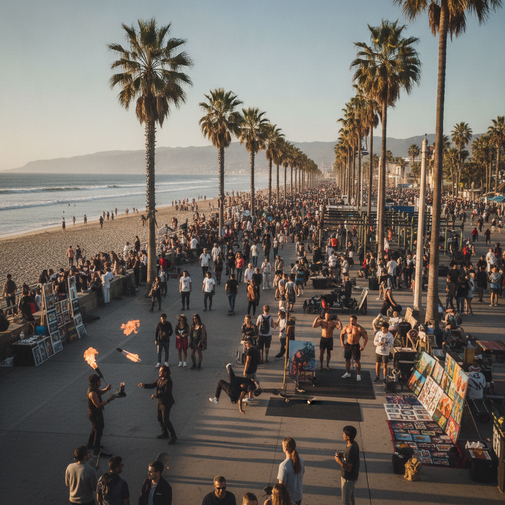
Venice Beach Boardwalk & Muscle Beach
The Venice Beach Boardwalk (Ocean Front Walk) — the 3-mile paved walkway along the beach from Washington Boulevard in the south to the Santa Monica city limit in the north — is the most eclectic public space in Los Angeles and one of the most photographed outdoor venues in the world. The boardwalk was created in 1905 as Abbott Kinney's resort promenade; the canals were filled to create it as an automobile road in 1929. It is now occupied by: Muscle Beach (the outdoor weightlifting gym, opened 1934, the birthplace of the American bodybuilding craze — Arnold Schwarzenegger trained here in the early 1970s, as did Jack LaLanne); the Venice Beach Skate Park (the most famous outdoor skate park in the world, completely free, featuring a bowl, street course, and 12-foot vertical wall); the daily art market (local artists selling paintings, jewelry, and sculptures under shade structures); and the Venice Boardwalk performers (fire eaters, snake handlers, fortune tellers, breakdancers, evangelists). The street food and reggae bars backing onto the boardwalk create a permanent festival atmosphere.
- 3
Main Street Venice & Rose Avenue
Main Street Venice — running parallel to the boardwalk two blocks inland from Washington Boulevard to Pico — is the residential and restaurant heart of Venice: lined with early 20th-century commercial buildings converted to restaurants, cafes, yoga studios, and independent shops, with the older, slightly run-down storefront character that the gentrification of Abbott Kinney has eliminated. The area around Rose Avenue (the intersection of Rose and Lincoln) has become Venice's newest concentration of creative businesses: the Google Venice campus (the largest employer in Venice, which helped drive the neighborhood's gentrification after 2012, earning it the nickname 'Silicon Beach'), Gjusta (the most celebrated artisan bakery and deli in Los Angeles, always with a line), and the Rose Cafe (1979, one of the Venice institutions, with a community bulletin board that still reflects the neighborhood's old character). The Venice Art Walls (on Windward Avenue, the city's official outdoor mural site) feature rotating murals by local and international street artists, the most significant public art in Venice.
- 4
Santa Monica Pier (1909/1921) & Route 66 End
The Santa Monica Pier — a combination of two adjacent piers (the Municipal Pier, 1909, and the Pleasure Pier, 1916, merged 1921) extending 1,600 feet into Santa Monica Bay — is the most visited tourist site in Los Angeles (approximately 8 million visitors per year) and the official end point of Route 66 (a sign at the pier's entrance marks the end of the 2,400-mile Chicago-to-Santa Monica highway, though Route 66 was officially decommissioned in 1985 and the pier wasn't its official end for most of its history — the actual terminus is debated). The pier contains: Pacific Park (the amusement park, with the solar-powered Ferris wheel that is the symbol of the pier), the Looff Hippodrome (1916, a National Historic Landmark, the carousel that appears in 'The Sting' with Paul Newman and Robert Redford and in 'Forrest Gump'), and the Santa Monica Pier Aquarium (run by Heal the Bay, free to children under 12, the touch tanks contain California sea creatures). The pier is the western terminus of the Marvin Braude Bike Trail.
- 5
Santa Monica State Beach & Third Street Promenade
Santa Monica State Beach — the 3.5-mile wide sandy beach extending from the Santa Monica Pier north to the Malibu city limit — is the most visited beach in the United States (approximately 15 million visitors per year) and the centerpiece of the Santa Monica Bay recreation area. The beach is wide (up to 300 feet of sand), clean (the Clean Beaches Initiative), and equipped with volleyball courts, bicycle rentals, and the Annenberg Community Beach House (1928, a Julia Morgan-designed estate now operated as a public pool and event center). Third Street Promenade — the 3-block pedestrian shopping street two blocks from the beach, developed in its current car-free form in 1989 — is the busiest pedestrian retail street in the western United States: chain stores, restaurants, and movie theaters anchored at each end by large shopping centers (the Santa Monica Place mall at the south end). The street performers (topiary dinosaurs, living statues, aspiring musicians) make it an outdoor entertainment venue after dark.
- 6
Palisades Park & Santa Monica Bluffs
Palisades Park — the narrow 26-acre clifftop park running 1.5 miles along the bluffs above Pacific Coast Highway from Colorado Avenue to Adelaide Drive, established in 1892 as one of Santa Monica's original public spaces — is the most pleasant public park in Los Angeles for its combination of views (the entire Santa Monica Bay from Point Dume to the Palos Verdes Peninsula, Catalina Island, and on clear days the Channel Islands), the gnarled eucalyptus and Moreton Bay fig trees (some dating to the 1880s), and its role as a refuge for the homeless population that has made Santa Monica their home. The Camera Obscura (in the Senior Recreation Center at Ocean Avenue and Broadway, free admission, operating since 1899, one of only a handful of camera obscuras in the United States) projects a live image of the beach and ocean below onto a table in a darkened room. The park overlooks the PCH and the beach below; the 1970s-era Holiday Inn (now the Loews Santa Monica) and the Jonathan Beach Club on PCH below were locations for Raymond Chandler's Philip Marlowe novels.