Machu Picchu, Cusco & Peru's Inca Heritage
Peru's Inca heritage (the archaeological legacy of the Inca Empire — the largest pre-Columbian empire in the Americas, which at its peak (1438-1533 CE) stretched 4,300 km (2,670 miles) from the southern border of modern Colombia to the central Chile coast, encompassing the territory of 6 modern nations): Machu Picchu (the Inca citadel on the mountain ridge above the Urubamba River — the most visited archaeological site in South America and one of the most iconic sites in the world) and Cusco (the 'navel of the world' — the capital of the Inca Empire) are accessible as a 1-2 day extension from Lima.
- 1
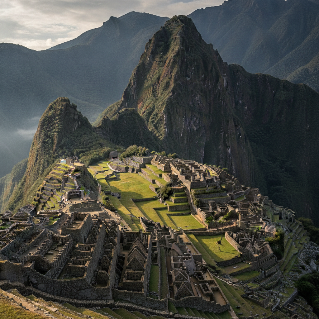
Machu Picchu — The Lost City of the Incas
Machu Picchu (the 'Old Mountain' in the Quechua language — the Inca citadel constructed in the mid-15th century (approximately 1450 CE) under the direction of the Inca emperor Pachacuti (Pachacuti Inca Yupanqui — the 9th Sapa Inca (Emperor of the Incas), the ruler who transformed the Inca state from a small kingdom into the largest empire in pre-Columbian America) on a narrow mountain ridge at 2,430 metres (7,970 feet) above sea level above the Urubamba River in the Cusco Region of Peru): the site (the archaeological site covering approximately 32,500 hectares (80,340 acres), of which the 'Urban Sector' (the main city, with its temples, palaces, plazas, and residential buildings) covers approximately 30 hectares (74 acres) — the site divided into the Agricultural Sector (the extensive agricultural terraces, or 'andenes', that covered the mountain slopes around the citadel) and the Urban Sector (the main citadel, with the Intihuatana stone (the 'hitching post of the sun' — the carved granite ritual stone whose purpose is debated but that is believed to have been used for astronomical observations and ritual purposes), the Temple of the Sun (the semi-circular tower of the finest Inca ashlar stonework), the Temple of the Three Windows (the long rectangular room with the three trapezoidal windows that are the most distinctive architectural feature of Machu Picchu), and the Principal Temple): the 'discovery' (the site was 'discovered' by the American historian and explorer Hiram Bingham III (1875-1956) on July 24, 1911 — although the site was known to local farmers and had been occupied seasonally by the Aguilar and Alvarez families in the decades before Bingham's arrival).
- 2
Cusco — The Inca Capital & Imperial City
Cusco (the 'Qusqu' in Quechua — the 'navel of the world', the capital of the Inca Empire (the 'Tawantinsuyu' — the 'Four Regions Together') at 3,399 metres (11,152 feet) above sea level in the Andes of Peru): the Inca city (the city that was the administrative, political, and religious centre of the Inca Empire at its height — the city planned in the shape of a puma (the sacred Andean feline) by the emperor Pachacuti, with the tail (the confluence of the Saphi and Tullumayo rivers), the body (the central city), and the head (the Sacsayhuamán fortress above the city)): the Spanish colonial overlay (the Spanish conquest of Cusco in 1533 by Francisco Pizarro — the conquistador who entered the city after the capture and execution of the Inca emperor Atahualpa — and the subsequent construction of the Spanish colonial city on the foundations and walls of the Inca city (the characteristic 'double layer' of Cusco — the Spanish colonial buildings with their baroque facades and arcaded plazas sitting on top of the perfectly fitted dry-stone Inca walls, the walls whose stones are fitted together without mortar with tolerances of less than 0.5 mm)): the Plaza de Armas (the main square of colonial Cusco — the 'Huacaypata' (the Inca great plaza) rebuilt by the Spanish as the Plaza de Armas, flanked by the Cathedral of Cusco (the 1654 baroque cathedral built with the stones from the Inca temple of Viracocha) and the Iglesia de La Compañía de Jesús (the 1571 Jesuit church).
- 3
The Inca Trail & Sacred Valley
The Inca Trail (the most famous trekking route in South America — the 43-km (27-mile) trek from the Km 82 trailhead on the Urubamba River to Machu Picchu, passing through cloud forest, mountain passes, and Inca archaeological sites over 4 days and 3 nights): the trail (the trail that follows the original Inca qhapaq ñan (the royal road of the Inca Empire — the 30,000-km (18,600-mile) road network that connected the entire Inca Empire from Colombia to Chile and Argentina) from the Sacred Valley to Machu Picchu, passing through the mountain passes of the Warmiwañuska ('Dead Woman's Pass' — at 4,215 metres / 13,828 feet above sea level, the highest point of the Inca Trail) and the Phuyupatamarka ('Town in the Clouds' — the Inca site at 3,600 metres / 11,810 feet above sea level, with the most spectacular view of the surrounding mountains on the entire trail)): the Sacred Valley of the Incas (the Urubamba Valley between Pisac and Ollantaytambo — the fertile valley below Cusco that was the agricultural and spiritual heartland of the Inca Empire, dotted with the Inca terraced sites (the Pisac ruins above the colonial market town of Pisac), the Moray agricultural experiment (the concentric circular terraces of Moray — the Inca agricultural laboratory where different microclimates were created by the depth of each terrace to experiment with crop cultivation), and the fortress of Ollantaytambo (the most complete Inca military and religious complex in Peru, and the starting point for the train to Aguas Calientes and Machu Picchu).
- 4
Lake Titicaca & the Altiplano
Lake Titicaca (the 'Quta Mama' — 'Lake Mother' in Aymara — the high-altitude lake at 3,812 metres (12,507 feet) above sea level on the Altiplano between Peru and Bolivia — the highest navigable lake in the world, the largest lake in South America by volume, and the most sacred lake in Andean cosmology (the lake from which, according to Inca mythology, the first Inca (Manco Cápac) emerged from the island of Isla del Sol to found the Inca Empire)): the Peruvian shore of Lake Titicaca (the Puno Region of Peru — the city of Puno (the 'Capital of Folklore' of Peru) at 3,827 metres (12,556 feet) above sea level on the western shore of the lake — accessible from Lima by 70-minute flight (LATAM and others fly Lima-Juliaca, the nearest airport to Puno) or by 18-hour overnight bus from Cusco): the Uros Islands (the 'floating islands of the Uros' — the 40+ artificial reed islands on the surface of Lake Titicaca, constructed and inhabited by the Uros people (the pre-Inca people who built their islands from the totora reeds (Schoenoplectus totora) that grow in the shallows of the lake and who live on these floating islands, fishing and weaving totora products)): the Isla Taquile (the natural island in Lake Titicaca whose Quechua-speaking Taquile people maintain the weaving tradition that was declared a UNESCO Intangible Cultural Heritage of Humanity in 2005 — the men of Taquile who wear the distinctive knitted chullos (the earflap caps) and weave the finest textiles on the lake.
- 5
Amazon Rainforest & Puerto Maldonado
Peru's Amazon (the Peruvian Amazon — the 'Madre de Dios' region (the 'Mother of God') in southeastern Peru, the most biodiverse region in the most biodiverse country on earth (Peru has the second highest number of bird species (1,878 species), the second highest number of mammal species, and the second highest number of plant species of any country in the world)): Puerto Maldonado (the capital of the Madre de Dios region — the gateway to the Peruvian Amazon, accessible from Lima by 1-hour flight (LATAM and others fly Lima-Puerto Maldonado)): the Tambopata National Reserve (the 274,690-hectare (679,000-acre) nature reserve east of Puerto Maldonado — the reserve with the highest documented biodiversity density of any protected area in the world: the 600+ bird species (including 46 species of parrots and macaws), the 1,200+ butterfly species (more butterfly species than in all of Europe), and the 169 mammal species (including the giant otter (Pteronura brasiliensis), the jaguar, the tapir, the giant anteater, and the 11 species of primates)): the clay licks (the 'collpas' — the mineral-rich clay banks along the Amazon rivers that attract the macaws, parrots, and other birds who consume the clay to neutralize the toxins in their food — the Colpa de Guacamayos (the macaw clay lick on the Tambopata River — the most spectacular birdwatching spectacle in Peru, with hundreds of red and green macaws descending to the clay bank at dawn).
- 6
Huacachina & Peru's Pacific Desert
Huacachina (the 'Oasis of the Americas' — the natural oasis in the Ica Desert of the Peruvian Pacific coast, 5 km (3 miles) west of the city of Ica and 300 km (186 miles) south of Lima): the Huacachina oasis (the small lake (approximately 300 metres / 984 feet in diameter) surrounded by palm trees and sand dunes (the dunes reaching heights of up to 100 metres (330 feet) above the desert floor — the highest sand dunes in the Americas), the small resort town of white colonial buildings that ring the lake): the activities (the sandboarding (the sport of riding the sand dunes on a snowboard-style board — Huacachina is the sandboarding capital of the world, with visitors taking the buggy tours that drive to the tops of the dunes and then sandboarding down) and the dune buggy tours (the high-speed buggy tours that climb and descend the dunes around Huacachina at sunset — the most thrilling activity available at Huacachina)): the Nazca Lines (the Nazca Lines — the geoglyphs created in the Nazca Desert by the Nazca culture (approximately 100 BCE - 800 CE) — 200 km (124 miles) south of Lima, the geoglyphs (the giant line drawings of animals, plants, and geometric shapes, ranging in size from 30 metres (98 feet) to 370 metres (1,214 feet)) visible only from the air — accessible by light aircraft from Nazca airport).