Sai Kung & Clear Water Bay: Hong Kong's Wild East
Sai Kung (西貢, 'Western Tribute') — the easternmost district of the New Territories, nicknamed 'Hong Kong's back garden' — encompasses the Sai Kung Peninsula Country Park (the largest country park in Hong Kong at 7,471 hectares), Sai Kung Town (the most famous seafood destination in Hong Kong), and the volcanic rock formations of High Island Reservoir that are inscribed on UNESCO's Global Geopark list as evidence of a catastrophic volcanic eruption 140 million years ago.
- 1
Sai Kung Town Waterfront & Seafood Restaurants
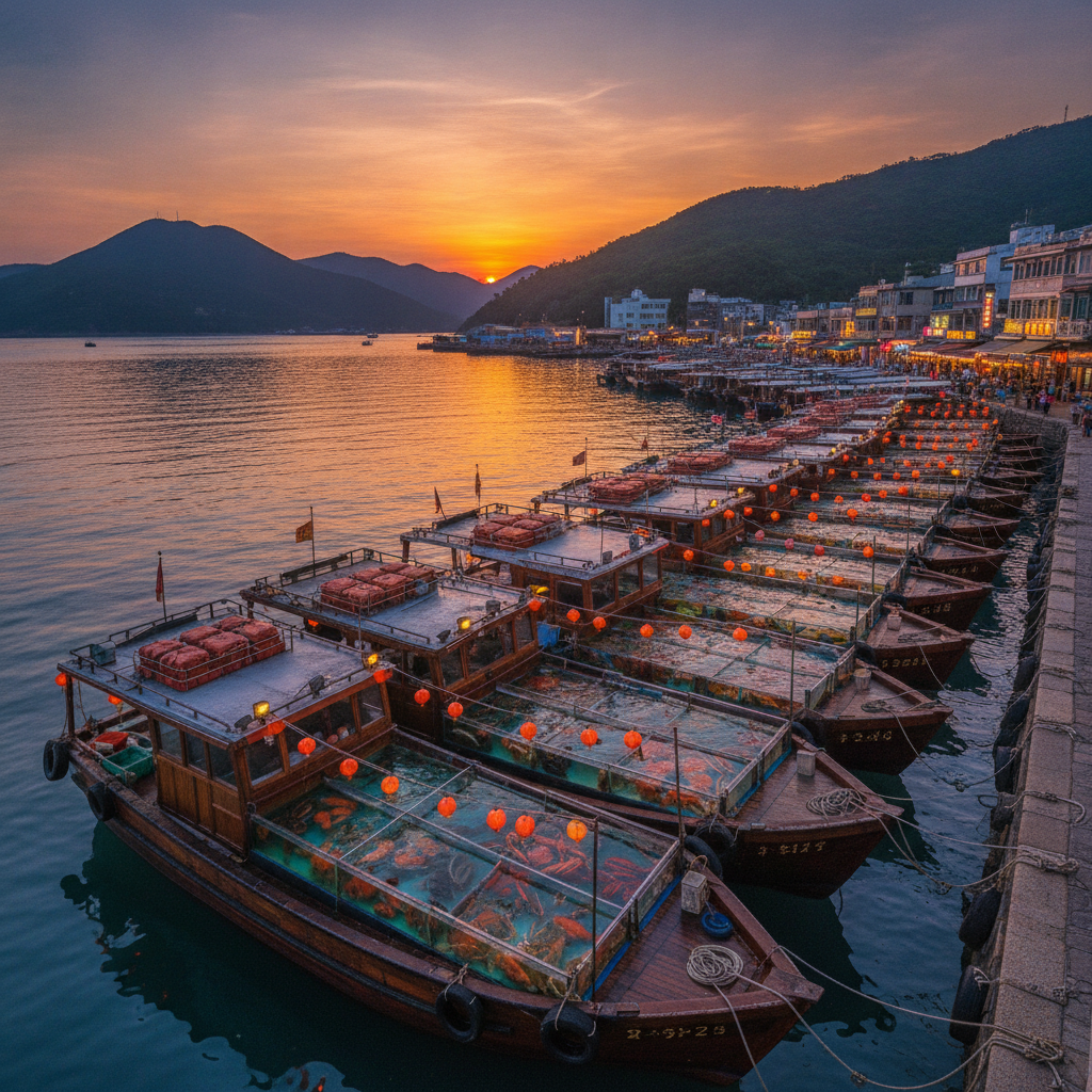
Sai Kung Town (西貢市, the main town of the Sai Kung district, situated on the western shore of the Sai Kung Peninsula on a natural harbour formed by several small islands; the town has a population of approximately 15,000 but receives many times that number of weekend visitors who come primarily for the seafood restaurants that line the main promenade (Po Tung Road and Yi Chun Street) and, most famously, the seafood restaurant boats moored along the Sai Kung Ferry Pier — sampan-sized boats with live tanks of fish, lobster, crab, prawn, abalone, and shellfish moored end to end along the pier, from which diners choose live seafood that is then cooked on the boat or in the adjacent restaurants; the seafood restaurant boats are the most widely photographed image of Sai Kung and are one of the most distinctive street-food market experiences in Hong Kong; the town also has a covered market (Man Yiu Street, the wet market selling fresh fish, vegetables, and Chinese herbs), a colonial-era church (St. Joseph's Church, built in 1890 by the Paris Foreign Missions, the oldest standing church in the New Territories), and a promenade walk around the harbour.
- 2
Sai Kung Country Park — Hiking, Beaches & Volcanic Hexagonal Columns
Sai Kung Country Park (Sai Kung Country Park and Sai Kung East Country Park combined, 7,471 hectares, the largest country park in Hong Kong and one of the most diverse: the park encompasses the entirety of the Sai Kung Peninsula east of Pak Tam Road, including the High Island Reservoir and its volcanic hexagonal rock columns — listed as part of the Hong Kong UNESCO Global Geopark (designated 2009) for the evidence they provide of a massive eruption of acid magma approximately 140 million years ago that formed hexagonal column formations similar to those of the Giant's Causeway in Northern Ireland but on a larger scale; the park contains over 50 individual beaches, most accessible only by boat or on foot via the Maclehose Trail; the most accessible beaches include Pak Sha Wan ('Whitesand Bay', Ham Tin Wan, and Tai Long Wan, the last considered by many hikers to be the most beautiful beach in Hong Kong: a remote 1.5-kilometre beach accessible only by a 3-hour hike via the Maclehose Trail Stage 2 or by boat from Sai Kung Town, with clear turquoise water, a narrow sandy beach backed by green hills, and a near-total absence of facilities or crowds).
- 3
High Island Reservoir & Geopark Hexagonal Columns (1978)
High Island Reservoir (High Island, Sai Kung East Country Park, the reservoir completed in 1978 by enclosing the sea inlet between High Island and the mainland of the Sai Kung Peninsula with two dams — the East Dam and the West Dam; when completed, it was the largest reservoir in Hong Kong, providing 28% of Hong Kong's freshwater needs — a significant achievement given that Hong Kong's water supply has historically been constrained by the small land area and high population; the reservoir is now most famous for the volcanic hexagonal rock columns exposed in the reservoir walls at the Geo Trail that begins at the East Dam carpark: the columns were formed 140 million years ago when massive outpourings of acid volcanic ash cooled and contracted into hexagonal formations similar to basaltic hexagonal column formations worldwide, but uniquely formed from acidic rhyolitic and tuffaceous material rather than the more common basaltic material; the scale of the Hong Kong volcanic event that produced these columns — which extend up to 100 metres in height — indicates an eruption comparable in magnitude to the Yellowstone supervolcano events).
- 4
Clear Water Bay Country Park & Clear Water Bay Beaches
Clear Water Bay Country Park (Clear Water Bay Road, Sai Kung District, the 6,565-hectare country park covering the Clear Water Bay Peninsula — the peninsula that forms the southern boundary of the Sai Kung District and separates Port Shelter from the open waters of the South China Sea — containing two of the most accessible beaches in the eastern New Territories (Clear Water Bay First Beach and Second Beach, two adjacent beaches on the western shore of the peninsula, connected by a coastal path; the beaches have clear water conditions similar to tropical resorts due to the direct exposure to the South China Sea and the absence of industrial runoff from the peninsula, and are typically ranked among the top five beaches in Hong Kong in annual visitor surveys) and the Shaw Brothers Movie Studio (an abandoned but standing film studio that was the production center of the Shaw Brothers film company from 1961-1987, producing approximately 1,000 films during its operational period and being one of the most prolific film studios in Asia: the studio was built on a hillside overlooking Clear Water Bay and consisted of 12 permanent exterior sets replicating ancient Chinese architecture, historical battlefields, and traditional Hong Kong streetscapes, all still standing in various states of preservation as of 2024).
- 5
Pak Tam Chung & MacLehose Trail Stage 1 (1979)
Pak Tam Chung Visitor Centre (Pak Tam Chung, Sai Kung, the visitor centre and park management headquarters for Sai Kung Country Park — the starting point for the MacLehose Trail Stage 1 from Pak Tam Chung to Long Ke Wan (10.6 km, 3-4 hours) and Stage 2 from Long Ke Wan to Pak Tam Au (13.5 km, 5-6 hours)) — the MacLehose Trail (麥理浩徑, the 100-kilometre trail from Pak Tam Chung in Sai Kung to Tuen Mun in the western New Territories, inaugurated in 1979 and named after Murray MacLehose, Governor of Hong Kong 1971-1982, who was the architect of Hong Kong's country park system; the MacLehose Trail is the longest country trail in Hong Kong and the most celebrated, passing through 8 country parks and 4 special areas; the annual Oxfam Trailwalker competition (in which teams of 4 attempt to walk the entire 100-kilometre trail within 48 hours) was established in 1981 as the original Trailwalker event from which all subsequent international Trailwalker competitions derive).
- 6
Wong Shek Pier & Outer Islands of the Sai Kung Peninsula
Wong Shek Pier (Wong Shek, Pak Tam Road, Sai Kung, the pier at the end of the road that serves as the departure point for boat services to the remote villages, beaches, and islands of the Sai Kung Eastern Country Park — kaito (街渡) ferry services operate from here to Chek Keng, Ko Tong, Pak Sha O, and other remote villages on the Sai Kung Peninsula that are accessible only by boat; the pier is also the access point for Ko Lau Wan and Sharp Island (Kiu Tsui Country Park), the volcanic geopark island accessible by sampan from Sai Kung Town that features hexagonal rock columns similar to the High Island Reservoir formations and a narrow sand bar (the tombolo) that connects the island to a smaller island at low tide) — the outer islands of the Sai Kung region include Tung Lung Chau (with a Qing Dynasty fort and some of the finest rock climbing in Hong Kong), Shelter Island, Tin Ha Wan, and the islands around Port Shelter, which together form one of the most diverse and least-visited archipelagoes in Hong Kong.