Ha Long Bay Versus the World: 1,969 Islands Against Phang Nga Bay's 42, the 1992 Indochine Oscar That Built the Bay's European Reputation & the Month-by-Month Guide That Actually Matters
Ha Long Bay's 4× Phang Nga Bay area with 50× more islands but worse environmental management despite the UNESCO designation—the undesignated Thai bay having more effective boat permit limits; the multi-day Lan Ha Bay kayak circuit from Cat Ba Town requiring intermediate sea kayak skills and accessing the floating homestay USD 20–30 per night; the Hà Tu opencast mine producing 3 million tonnes of anthracite annually as the primary sedimentation source for the UNESCO heritage water; WWF Vietnam's RTHL programme membership as the most reliable cruise operator selection criterion; 'The Quiet American' 1955 novel's unnamed northern Vietnamese landscape now firmly identified as Ha Long Bay by literary tourism; and March as the best mist photography month when the temperature differential is right but the summer crowds haven't arrived.
- 1
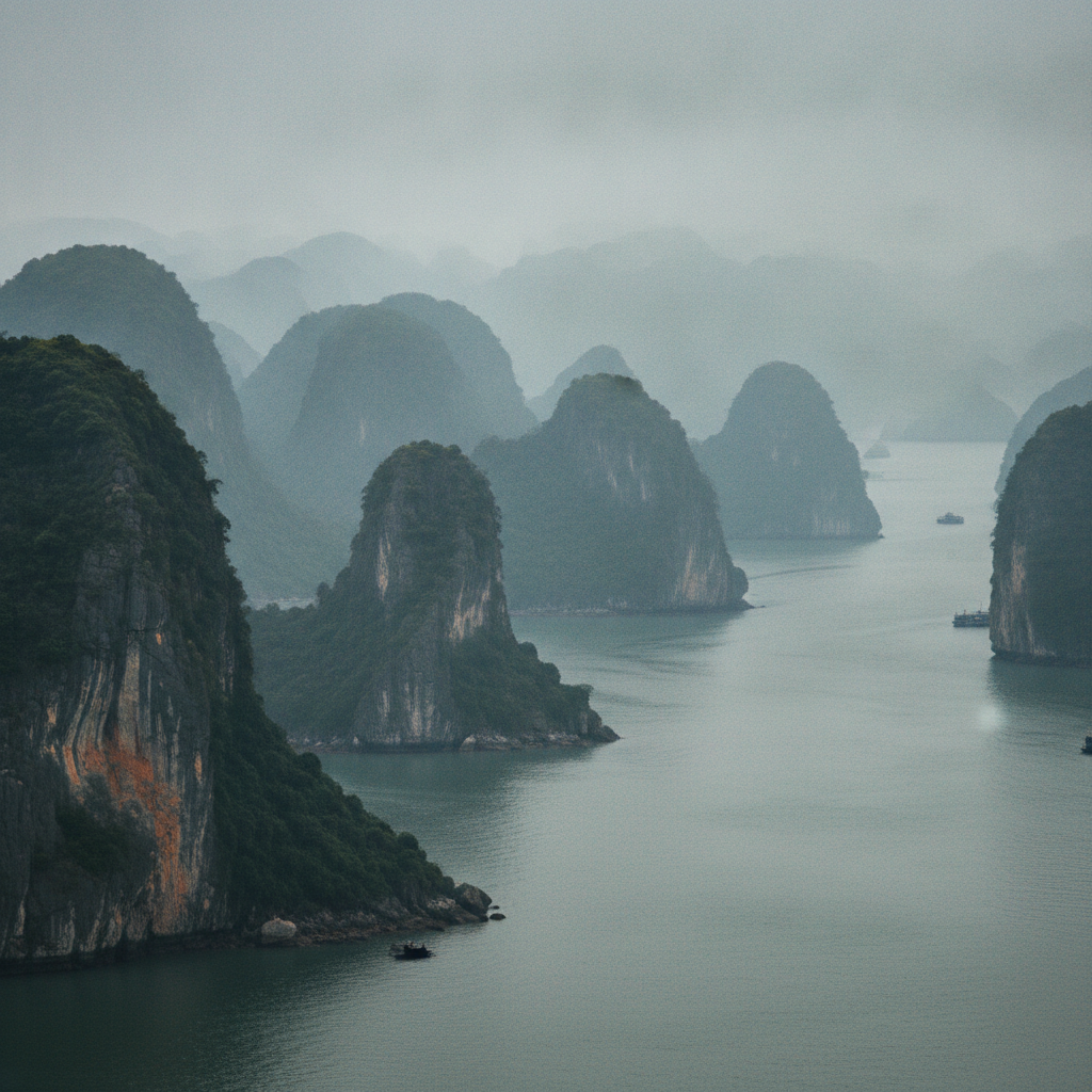
Ha Long Bay vs. Phang Nga Bay – The World's Karst Seascapes
Ha Long Bay is most frequently compared to Phang Nga Bay (the limestone karst bay in southern Thailand, 100 km north of Phuket—the 'James Bond Island' location, with 42 karst islands in a 400 km² bay) in travel media rankings of karst landscapes: the comparison illuminates what makes each site specific. The scale difference: Ha Long Bay (1,553 km², 1,969 islands) is approximately 4× larger than Phang Nga Bay in area and contains approximately 50× more islands—the scale difference creates qualitatively different experiences (Ha Long Bay's karst is experienced as an encompassing landscape; Phang Nga Bay's is experienced as individual island punctuations in a bay). The geology comparison: both bays share the same karst limestone formation process (Permian-age limestone, tropical dissolution, tower karst) but the Ha Long Bay towers are taller (some exceeding 100 metres above water versus the Phang Nga Bay maximum of approximately 30–40 metres above water), have more dramatic overhanging bases, and contain more extensive cave systems. The tourism comparison: Phang Nga Bay (100 km from Phuket, accessible by day trip) hosts approximately 1 million visitors per year versus Ha Long Bay's 4+ million; the Phang Nga management (national park designation; strictly enforced boat permit limits) is generally considered more effective than the Ha Long Bay management—the irony is that Ha Long Bay's UNESCO status has attracted more tourist investment and more boat permits than the undesignated but better-managed Phang Nga Bay.
- 2
The Ha Long Bay Kayak Circuit – A Multi-Day Independent Plan
The multi-day independent kayak circuit of Ha Long Bay and Lan Ha Bay—using Cat Ba Island as a base, renting a sea kayak, and paddling to the anchorages in Lan Ha Bay each night (staying in the few remaining permitted floating accommodation structures)—is the most intimate and most physically demanding Ha Long Bay experience, available to visitors with intermediate sea kayak skills. The route: Day 1: Cat Ba Town to Ao Ech Bay (12 km—the most sheltered route, through the Lan Ha Bay inner islands); Day 2: Ao Ech Bay to the Dark and Bright Cave (8 km—the cave circuit in the western Lan Ha, the highlight of the kayak circuit); Day 3: Dark and Bright Cave to the Cannon Fort area (6 km—the Cannon Fort viewpoint on Cat Ba Island, accessible from the water, with the best panoramic views of the Lan Ha Bay). The logistics: the Cat Ba kayak rental (USD 10–20/day for a sea kayak with basic safety equipment); the Cat Ba Island kayak guide services (USD 30–50/day for a local guide who knows the currents, the anchoring spots, and the cave timing at low tide); the overnight accommodation (the floating homestay in Lan Ha Bay—the only remaining permitted floating accommodation in the Ha Long system, USD 20–30/person including meals). The physical requirement: the Lan Ha Bay paddle requires 4–6 hours of sustained paddling per day with loaded equipment—appropriate for regular sea kayakers, not suitable for beginners.
- 3
The Quảng Ninh Coal Mining Landscape
The Quảng Ninh coal mining landscape—the industrial environment immediately adjacent to the Ha Long Bay tourist landscape, visible from the bay in some orientations as the coal-loading conveyor belts and mining equipment on the shore—is the most significant environmental threat to the UNESCO World Heritage Site and the most clearly unsustainable element of the Quảng Ninh provincial economy. The Hà Tu coal mine: the opencast coal mine at Hà Tu (8 km east of Ha Long City; producing approximately 3 million tonnes of anthracite annually; the most visible mine from the Ha Long Bay tourist zone) has been identified in multiple UNESCO monitoring reports as the primary source of the sedimentation affecting the bay's marine environment. The provincial dilemma: Quảng Ninh province earns approximately USD 1.5 billion per year from coal mining and approximately USD 350 million from tourism; the provincial government's choice between short-term coal revenue and long-term tourism sustainability has consistently favoured coal production, with promises of mine rehabilitation that have not been systematically implemented. The timeline: the most optimistic projection in the Quảng Ninh provincial master plan (2020–2030) envisages the cessation of active coal mining within 15 km of the Ha Long Bay boundary by 2030—a projection that is currently behind schedule.
- 4
Ha Long Bay Responsible Tourism – What Actually Helps
The responsible tourism framework for Ha Long Bay—developed by the Hội An Eco Tourism network, the World Wildlife Fund Vietnam, and the cruise industry associations—provides practical guidance for visitors who want to minimise their environmental impact in one of the world's most environmentally sensitive tourism destinations. The operator selection: the most reliable indicator of a responsible Ha Long Bay cruise operator is membership in the Responsible Tourism in Ha Long (RTHL) programme (managed by WWF Vietnam and the Quảng Ninh Tourism Department)—RTHL members are audited for waste management practices, wastewater treatment, crew welfare, and wildlife interaction guidelines. The guest behaviour: no touching or standing on coral (kayak tours); no single-use plastic (the responsible operators provide reusable water bottles and filter water on board); no wildlife feeding (the monkeys on the karst cliff faces have been habituated to human food by decades of tourist feeding, disrupting their foraging behaviour); no purchasing of sea shells, turtle products, or live animals from floating market vendors. The community contribution: booking a cruise that includes the Cua Van community programme (the former floating village community now operating tourism services from their onshore relocation site—cooking demonstrations, craft workshops, guided tours of the former village area) directs tourism revenue to the most economically displaced community in Ha Long Bay.
- 5
Ha Long Bay in Film & Literature
Ha Long Bay's cinematic and literary presence—the most internationally recognised Vietnamese landscape in global media—has made the bay a specific type of aspirational destination: one where visitors arrive having seen the landscape in multiple formats before standing in it. The films: 'Indochine' (the 1992 French film directed by Régis Wargnier, starring Catherine Deneuve, which won the Academy Award for Best Foreign Language Film—the most internationally seen film featuring Ha Long Bay; the scenes shot in the bay became the defining image of French Indochina nostalgia in European cinema); 'The Quiet American' (the 2002 Michael Caine film adaptation of Graham Greene's novel, which filmed in Ha Long Bay; the bay stands in for the atmospheric Vietnamese landscape that Greene's 1955 novel describes without specifically naming); 'Skull Island: Reign of Kong' (the 2016 film franchise that used the Ha Long Bay landscape as the basis for the Kong Skull Island environment—the digital extension of the real landscape into a mythological one). The literature: the Graham Greene 'The Quiet American' (the novel's unnamed northern Vietnamese landscape is now firmly identified by Vietnamese literary tourism as Ha Long Bay, regardless of Greene's actual geographical reference); the Peter Matthiessen 'The Cloud Forest' (the naturalist writer's 1961 journal of travel through Asia that includes Ha Long Bay at its pre-tourism scale—the comparison with the present is the most sobering measurement of what has been lost and gained in 60 years).
- 6
Ha Long Bay Weather Windows – The Month-by-Month Guide
The Ha Long Bay climate—the most frequently queried practical topic for visitors planning a northern Vietnam trip—varies significantly by month in a pattern that differs from the simple 'wet/dry' description given by most travel resources. January: drizzle and mist, 15°C, fewest tourists, most atmospheric photography; low visibility for snorkelling. February: similar to January but with slightly warmer temperatures and the approach of Tết (Vietnamese New Year—cruise prices spike during Tết week). March: the transition month—the mist begins to lift, temperatures rise to 18–22°C, visibility improving; the best month for the mist photography if the temperature is right. April–June: the best season overall—clear water, good visibility, temperatures 25–30°C, the southeast wind bringing cleaner air; the golden season before the summer crowd. July–August: the peak tourist season—the most crowded, the hottest (33°C+), the highest typhoon risk; the cruise prices at their highest; the bay at its most environmentally stressed. September: post-peak, still hot but crowds reducing; the highest typhoon risk month—check weather carefully before booking. October–November: the second-best season (approaching the perfect conditions of April–June); the light is better for photography in October–November than in April–June; prices are lower than summer. December: the cool season begins; Christmas and New Year prices spike; the bay is pleasant (20–25°C) but the mist is beginning to build for January.