Palawan's Wider World: Puerto Princesa's 8.2km Underground River, the Tagbanua's 50,000-Year Presence & the 14.7km San Vicente Beach That Refused Boracay's Fate
The Puerto Princesa cave's 800,000 Geoffroy's rousette bats exiting each evening in a 30-minute mass flight before the last paddle boats return; the Tagbanua CADC ancestral domain over Calamian islands where their traditional fishing bans constitute one of the Philippines' earliest community marine management systems; Nacpan's 4km beach requiring an unpaved road and offering beginner surf while Las Cabañas' cable car (the Philippines' only beach cable car) offers the sunset view for PHP 250; the 12 Japanese WWII ships sunk in Coron Bay by Admiral Halsey's Task Force 38 in September 1944 now at 10–45 metres in coral-colonised formations; live coral cover at 15% near Tour A destinations versus 55% in remote reef areas showing the direct tourism footprint impact; and San Vicente Long Beach at 14.7km deliberately unbranded to avoid the trajectory El Nido followed from 1,500 visitors in 2000 to 200,000 in 2019.
- 1
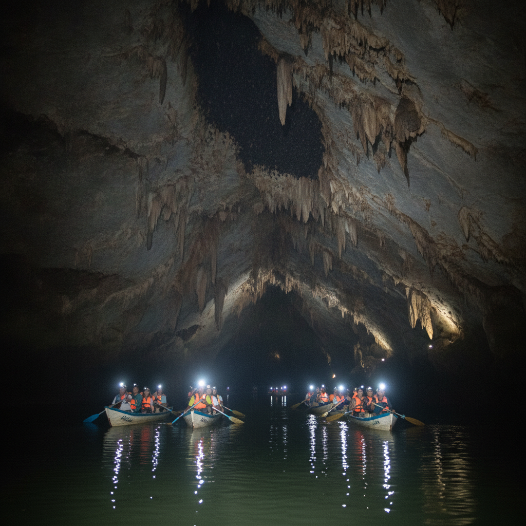
The Puerto Princesa Subterranean River – UNESCO's Underground World
The Puerto Princesa Subterranean River National Park (PPSRNP—a UNESCO World Heritage Site since 1999 and one of the New 7 Wonders of Nature since 2012)—is the most visited single attraction in Palawan, drawing approximately 300,000 visitors annually to the 8.2-km underground river that flows through a cathedral-like limestone cave system before emerging at the sea at Sabang Beach. The cave system: the river enters the cave at an inland jungle location and flows underground for 8.2 km (the navigable length—the full cave system extends 24 km but the inner section is only accessible to scientific expeditions), passing through a series of caverns with extraordinary stalactite and stalagmite formations: the Italian's Chamber, the Cathedral, the Garden of Eden, and the Cows (stalactite formations named for their resemblance). The biodiversity: the cave system supports a distinctive wildlife community—approximately 800,000 Geoffroy's rousette bats (Rousettus amplexicaudatus—roosting in the cave's upper sections, exiting each evening in a mass flight that takes 30 minutes and provides one of the most spectacular natural spectacles in the Philippines); the cave swiftlets (nesting on the cave walls); and the five species of sea snake that inhabit the tidal section of the river mouth. The access: all visitors to the cave must book a paddle boat tour (licensed guides only—maximum group size 8, tour duration approximately 45 minutes for the standard section); the Sabang Beach staging area has strict carrying capacity limits (approximately 900 visitors per day).
- 2
The Tagbanua People – Palawan's Indigenous Custodians
The Tagbanua (one of the oldest indigenous groups in the Philippines—their presence in Palawan is documented from at least 1,500 CE in Chinese trade records, and archaeological evidence suggests habitation for 50,000+ years)—are the indigenous people of northern and central Palawan and the Calamian archipelago, with traditional territories that overlap significantly with the Bacuit Archipelago and the El Nido marine zone. The Tagbanua's legal status: the Tagbanua have been granted a Certificate of Ancestral Domain Claim (CADC) over parts of the Calamian archipelago—a legal recognition of their traditional territorial rights that predates most Philippine indigenous rights legislation. The Tagbanua's relationship with the El Nido tourism economy: the community faces the classic tension between the economic opportunities of tourism (employment as tour guides, boat crew, and accommodation staff) and the cultural and ecological disruption of mass tourism in their ancestral territory. The Tagbanua sacred sites: several of the Bacuit Bay islands (including specific lagoons and caves) are designated sacred (sacral areas where Tagbanua conduct ceremonies for the sea spirit—the 'Lord of the Sea'—that must not be disturbed); some of the current tour sites are in or adjacent to these areas, creating a conservation-religion-tourism conflict. The conservation stewardship: the Tagbanua's traditional fishing practices (banning fishing during certain seasons, protecting specific reef areas from nets) constitute one of the earliest examples of community-based marine resource management in the Philippines.
- 3
El Nido's Beaches – Nacpan, Las Cabañas & the Mainland Shore
The beaches of the El Nido mainland—the long stretches of sand on the Palawan coast immediately surrounding the town—provide an alternative to the island-hopping circuit for visitors who prefer a less structured beach experience. Nacpan Beach (4 km of white sand, 45 minutes by motorbike from El Nido town on an unpaved road—or accessible by Tour D variation): the longest and most uncrowded beach in the El Nido area, with consistently good surf conditions (best October–March) for beginner surfing, calm clear water for swimming at the northern end, and a handful of beachside restaurants serving the combination of fresh seafood and cold beer that constitutes the El Nido beach lunch ideal. Duli Beach (15 km north of El Nido town): even more remote than Nacpan, reached by an additional section of unpaved road—a beach that, as of 2023, had only one simple restaurant and no accommodation on the beach itself (a few small eco-lodges were 500 metres inland). Las Cabañas Beach (10 minutes' walk south of El Nido town): the closest beach to the town centre—a 500-metre sandy beach directly accessible without a boat, with a cable car (the only beach cable car in the Philippines—PHP 250 return) running to an offshore reef platform with a panoramic view of the sunset over the limestone towers. The sunset view: from the cable car platform or from the Las Cabañas Beach viewpoint, the El Nido sunset (the limestone towers silhouetted against the orange sky over the South China Sea) is the most photographed sunset in the Philippines.
- 4
The Coron Connection – WWII Wrecks & the Calamian Islands
Coron (the main town on Busuanga Island in the Calamian archipelago—accessible from El Nido by fast speedboat in 3–4 hours, or from Puerto Princesa by bus and ferry in 8+ hours)—is the primary destination for those who combine El Nido's island-hopping with the WWII wreck diving that is Coron's specific offering. The WWII context: on 24 September 1944, the US Navy Task Force 38 (under Admiral Halsey) conducted a surprise air raid on the Japanese fleet sheltering in Coron Bay—sinking 12 supply ships and tankers in a single action; the ships sank in 10–45 metres of water and have been colonised by coral and marine life over 80 years, creating a reef system unique in the Philippines. The dive sites: the Irako (a Japanese refrigerator ship, 147 metres long, now at 40 metres depth—the largest wreck accessible to recreational divers in Coron); the Akitsushima (a Japanese seaplane tender with a decompression chamber and fuel tanks intact—46 metres); and the Kogyo Maru (partially penetrable at 25–35 metres, with engine room and cargo hold accessible with a guide). Kayangan Lake (on Coron Island, accessible by outrigger boat from Coron town—a freshwater lake in the interior of Coron Island's karst formation, consistently rated the 'cleanest lake in Asia' by Philippine tourism materials; the viewing platform overlooks the lake from a rocky cliff, providing the most reproduced landscape photograph in the Calamian archipelago). The Coron town character: significantly less developed than El Nido—the town of 35,000 people retains a more working-class atmosphere, with fewer international tourists and a more Philippine-domestic visitor profile.
- 5
El Nido's Coral Reefs – Marine Conservation & Reef Health
The marine environment of the Bacuit Bay—the combination of the open South China Sea on the west, the protected lagoons within the archipelago, and the coral reef systems covering the underwater bases of the limestone towers—is among the most biodiverse marine environments in the Philippines, though under significant pressure from the explosive growth of island-hopping tourism. The El Nido Marine Reserve (established 1984—one of the earliest marine protected areas in the Philippines): a 90,000-hectare protected area covering the Bacuit Bay and adjacent marine waters; the DENR (Department of Environment and Natural Resources) and the local government have authority over the reserve, but enforcement historically has been inconsistent. The coral reef status: surveys conducted by the Reef Check Philippines network (2018–2022) found that live hard coral cover in the Bacuit Bay ranges from 15% (the most heavily visited snorkelling sites adjacent to Tour A destinations) to 55% (remote reef areas rarely visited by island-hopping tours)—a significant range that indicates the direct impact of tourism footprint on reef health. The anting threat: the crown-of-thorns starfish (Acanthaster planci—the coral-eating starfish that periodically outbreaks and can devastate coral reefs within its range) caused a significant reef mortality event in the northern Bacuit Bay in 2015–2016; manual removal programmes by El Nido Resorts' marine conservation team removed 14,000+ specimens. The dugong population: Palawan is one of the last Philippine provinces with a resident dugong (Dugong dugon) population—small groups of 3–8 animals are occasionally sighted in the seagrass meadows of the inner Bacuit Bay and the Coron area.
- 6
Beyond El Nido – Palawan South & the Road to Puerto Princesa
The southern half of Palawan—the route from El Nido south along Palawan's spine to Puerto Princesa (the provincial capital, 5.5 hours by van or bus on the paved National Road)—passes through a series of less-visited destinations that provide the most complete picture of Palawan's extraordinary natural and cultural landscape. The Taytay area (120 km south of El Nido): the site of Fort Santa Isabel (a 1667 Spanish colonial fort—the most intact historical structure in Palawan, built to defend against Muslim raids from Mindanao), and the access point for several unexplored diving islands (Apulit Island—where El Nido Resorts operates a third property in the Calamian area). The San Vicente Long Beach (the longest beach in the Philippines at 14.7 km—accessible from San Vicente town, 100 km south of El Nido): not yet commercially developed, with the local government of San Vicente actively managing development to avoid the Boracay and El Nido trajectories—the beach has limited accommodation (a few eco-lodges, no chains) and is proposed for sustainable tourism development by the Department of Tourism. The Malampaya Sound (50 km southeast of Taytay): a large inland sea enclosed by mountains—the Malampaya Natural Gas Field (the largest natural gas deposit in the Philippines, the energy source for 30–40% of Metro Manila and Luzon's electricity during its peak production years) lies beneath this bay; the surface of the sound is home to nesting Philippine cockatoo and migratory shorebirds.