Christchurch: Post-Earthquake Rebuild, Botanic Gardens, Banks Peninsula and Akaroa French Colony, Kaikoura Whales, Arthur Pass Southern Alps, and Practical South Island Base Camp
Christchurch: the 2010-2011 earthquake story and the extraordinary urban rebuild, the Botanic Gardens and Avon River green heart, Banks Peninsula volcanic geology and Akaroa French settlement, Kaikoura whale watching and seabird richness, the TranzAlpine rail and Arthur Pass, and Christchurch as the ideal South Island base.
- 1
Christchurch and the 2010-2011 Earthquakes - The Rebuild That Changed a City
Christchurch (population approximately 400,000): the largest city in the South Island of New Zealand and the gateway to the Canterbury Plains and the Southern Alps. The Christchurch earthquakes: the 7.1 magnitude earthquake of 4 September 2010 caused major structural damage but no fatalities; the 6.3 magnitude aftershock of 22 February 2011 struck at 12:51 pm (lunchtime, when the city center was full of people) and killed 185 people, making it the deadliest earthquake in New Zealand history since the 1931 Napier earthquake. The Christchurch Cathedral (the Anglican cathedral on Cathedral Square): severely damaged in the 2011 earthquake; after years of controversy, the decision was made to restore it. The Re:START Mall (the temporary container mall that opened in October 2011): the world first large-scale container mall, built from brightly painted shipping containers in the city center to restore retail commerce while the rebuild proceeded. The rebuild: the most ambitious urban reconstruction in New Zealand history.
- 2
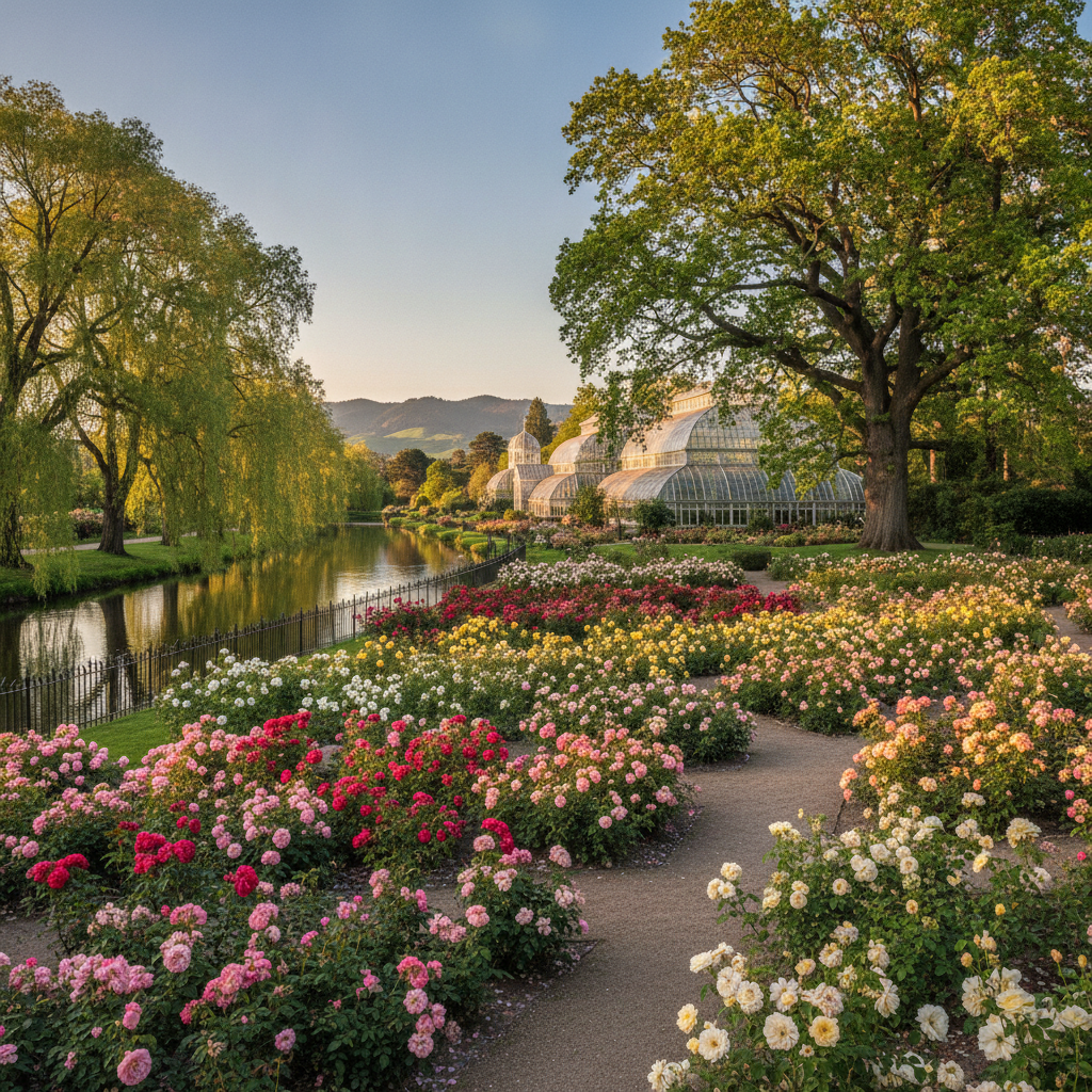
The Botanic Gardens, Hagley Park, and Avon River - Christchurch Green Heart
Hagley Park (165 hectares): the largest public park in any New Zealand city, and the largest park in the central city area, with the Christchurch Botanic Gardens (established 1863) at its center. The Botanic Gardens: 21 hectares of themed gardens including the rose garden, the water garden, the New Zealand native plant collection, the rock garden, and the glasshouses (including the tropical plant houses). The Avon River (Otakaro in te reo Maori): the meandering river that passes through the Hagley Park and the Botanic Gardens. The Avon River Precinct: the post-earthquake red zone along the Avon River (approximately 8 km of former inner city suburbs cleared after the earthquake to reduce risk) has been converted into a linear park. The punting on the Avon: the Edwardian tradition of flat-bottomed boat punting on the Avon River through the Botanic Gardens (operational since before the earthquakes and continuing through the rebuild). The Canterbury Museum (adjacent to the Botanic Gardens): the primary museum of the Canterbury region, with the Antarctic Hall (the most significant Antarctic heritage collection in the southern hemisphere).
- 3
Banks Peninsula - Akaroa and the French Connection
Banks Peninsula (the large volcanic peninsula east of Christchurch, approximately 85 km from the city center): the most distinctive geographic feature of the Canterbury region. The Banks Peninsula history: the remnant of two overlapping shield volcanoes (the Lyttelton and Akaroa calderas) that erupted approximately 9-11 million years ago. Lyttelton (the port town inside the Lyttelton Harbour, formed by the ancient Lyttelton caldera): the historic port through which all Christchurch imports and exports passed; the Lyttelton tunnel (opened 1964) provides the main road access through the Port Hills. Akaroa (approximately 85 km from Christchurch by road over the Port Hills and along the Banks Peninsula): the only French settlement in New Zealand. The Akaroa French history: 63 French settlers arrived in August 1840 to establish the French colony; the British had already claimed New Zealand sovereignty (Treaty of Waitangi, February 1840), so Akaroa became a French cultural enclave within British New Zealand. The Hector dolphin (the smallest and rarest marine dolphin in the world): endemic to New Zealand coastal waters; Akaroa Harbour is the most accessible place in New Zealand to swim with Hector dolphins.
- 4
Kaikoura - Sperm Whales and Seabird Central of the Pacific
Kaikoura (approximately 180 km north of Christchurch, 2.5 hours by road or the Coastal Pacific train): the whale watching capital of New Zealand and one of the most productive marine wildlife locations in the southern hemisphere. The Kaikoura Canyon: the submarine canyon that comes within 800 meters of the Kaikoura coastline and drops to 1,500 meters depth, creating an upwelling of nutrient-rich water that supports an extraordinary concentration of marine life. The sperm whale at Kaikoura: the year-round population of male sperm whales (Physeter macrocephalus, the largest toothed whale: males reach 18 meters and 50 tonnes) that feed in the Kaikoura Canyon. The Kaikoura seabird diversity: albatrosses (wandering, royal, shy, Salvin, Buller, and black-browed), petrels, shearwaters, prions, skuas, and the endemic Hutton shearwater (nesting only in the Seaward Kaikoura Range above the town). The 2016 Kaikoura earthquake (magnitude 7.8, the largest earthquake in New Zealand in 15 years): permanently uplifted the Kaikoura coastline by 0.5-2 meters, creating new land and exposing the sea floor.
- 5
Arthur Pass and the Southern Alps Crossing
Arthur Pass (the principal road and rail crossing of the Southern Alps, 154 km west of Christchurch): the primary route connecting the Canterbury Plains on the east with the West Coast on the west. Arthur Pass village (elevation 737 m): the highest altitude permanently inhabited settlement in the Southern Alps, in the Arthur Pass National Park. The TranzAlpine train (the scenic rail journey from Christchurch to Greymouth, approximately 4.5 hours): one of the most scenic rail journeys in the world, crossing the Canterbury Plains, climbing through the Waimakariri River gorge, passing through the Arthur Pass (via the 8.5 km Otira tunnel), and descending through the beech forest of the West Coast. The kea (Nestor notabilis): the world only truly alpine parrot, found above the treeline in the Southern Alps including at Arthur Pass. The kea is famous for its extreme intelligence and its curiosity: it will disassemble cars, steal food, and investigate any unfamiliar object. Castle Hill (80 km west of Christchurch): the extraordinary limestone rock formations used in the filming of The Chronicles of Narnia; the Dalai Lama declared Castle Hill the spiritual center of the universe.
- 6
Christchurch Practical Guide - Garden City, Arts Scene, and South Island Base Camp
Christchurch as South Island base camp: all major South Island destinations are accessible from Christchurch by road: Kaikoura (2.5 hours north), Queenstown (5 hours south via Tekapo), Mount Cook (3.5 hours south), Nelson and Marlborough Sounds (4-5 hours northwest), and the West Coast via Arthur Pass (4 hours). The Christchurch Arts Centre (the neo-Gothic buildings of the former University of Canterbury): the primary arts and culture hub of post-earthquake Christchurch, with galleries, studios, and cafes. The Christchurch arts scene post-earthquake: the earthquake destruction paradoxically stimulated one of the most creative urban art responses in New Zealand history. Christchurch Street Art: the Gap Filler organization used the hundreds of vacant earthquake lots to create temporary art installations, pocket parks, and community spaces. Isaac Theatre Royal (the Edwardian theatre): the major performing arts venue, completely restored after earthquake damage. Practical: Christchurch Airport (CHC): the second-busiest airport in New Zealand; direct flights to Auckland, Wellington, Queenstown, and major Australian cities. Best season: October to April (warm and sunny); winter (June-August) for skiing at Porters Pass (100 km west of the city).