Christchurch: Canterbury Plains and High Country, Waipara Wine, Lyttelton Harbour Volcanic Landscape, Antarctic Gateway, and Post-Earthquake Food and Arts Scene
Christchurch: the Canterbury Plains breadbasket, Rakaia Gorge high country, Waipara wine (Riesling and Pinot Noir), Lyttelton Harbour volcanic landscape and Port Hills, Christchurch as the gateway to Antarctica, and the innovative post-earthquake food and arts scene.
- 1
Canterbury Plains - The Breadbasket of New Zealand
Canterbury Plains: the largest area of flat land in New Zealand (approximately 180 km long by 60 km wide), formed by glacial outwash from the Southern Alps during the last glaciation. Canterbury is the primary agricultural region of New Zealand: the Canterbury Plains produce approximately 70% of New Zealand wheat, 75% of New Zealand barley, and significant quantities of oats, ryegrass seed, and vegetable seed. Canterbury sheep farming: the Merino sheep of the high country stations above the plains produce some of the finest wool in the world. The Mackenzie Basin (the inland high-country plateau beyond the Southern Alps foothills): the primary Merino and deer farming zone, with station runs covering hundreds of square kilometers. The Canterbury irrigation: the massive Canterbury Plains irrigation schemes (drawing water from the Southern Alps rivers) have transformed dry tussock grassland into intensive dairy and cropping land, causing significant water quality debates. The Rakaia River (the widest river in New Zealand by channel width, approximately 200 m): the braided rivers of Canterbury (the Waimakariri, Rakaia, Rangitata, and Waitaki) are all characteristic wide braided systems, impossible to bridge for most of their length.
- 2
Rakaia Gorge and the Canterbury High Country
Rakaia Gorge (approximately 110 km west of Christchurch): the narrow gorge where the Rakaia River cuts through the foothills of the Southern Alps, with the distinctive turquoise water of the glacially-fed river. The Rakaia Gorge walkway (3 hours return): the most accessible high-country gorge walk from Christchurch. Lake Coleridge (the hydro-electric lake in the foothills, approximately 120 km west of Christchurch): the oldest hydro-electric station in the South Island (opened 1914). Methven (the ski town in the Canterbury foothills, approximately 95 km from Christchurch): the primary service town for the Mount Hutt ski area. Mount Hutt (ski area, elevation 2,086 m): one of the largest ski areas in the South Island, with reliable snow and the longest ski season in New Zealand (typically June to October). The Geraldine and Pleasant Point area (approximately 130 km south of Christchurch): the transitional zone between the Canterbury Plains and the Mackenzie Basin, with the Giant Jersey (the world largest jersey knit sweater, on display at Geraldine, a reference to the importance of wool in the Canterbury economy).
- 3
Waipara Wine Region - Canterbury Pinot Noir and Riesling
Waipara (North Canterbury wine region, approximately 60 km north of Christchurch): the primary wine region of the Canterbury region, famous for Pinot Noir, Riesling, and Pinot Gris. The Waipara Valley: sheltered from the coastal winds by the Teviotdale Hills, creating a warmer and drier microclimate than the Christchurch coast; the soils are the free-draining limestone-clay loams ideal for aromatic white wines. The Pegasus Bay Winery (founded 1986): one of the founding wineries of the Waipara region, producing benchmark Rieslings and Pinot Noirs. The Muddy Water Winery, Mountford Estate, and Lowburn Ferry Estate: key Waipara producers contributing to the growing international reputation of Canterbury wine. The Waipara wine style: the Canterbury Riesling is described as having a distinctively austere and mineral character compared to the more floral Marlborough Riesling. The North Canterbury wine tourism circuit: wineries clustered along State Highway 1 north of the Waipara River, with most offering cellar door tastings (Friday to Sunday in season). Waipara combined with Kaikoura (60 km further north): the ideal one-day or two-day road trip north of Christchurch.
- 4
Lyttelton Harbour and the Port Hills Volcanic Landscape
The Port Hills (the ridge separating Christchurch from Lyttelton Harbour): the remnant of the ancient Lyttelton Volcano caldera rim, rising to 445 m (Mount Pleasant). The Summit Road (the road following the Port Hills ridge crest, with views of both Christchurch and Lyttelton Harbour): the most scenic drive accessible from central Christchurch. Sign of the Takahe (the stone rest house on the Port Hills, built 1918): the historic tram stop and tea house on the Cashmere Hills. Lyttelton (the port town inside the Lyttelton caldera): the most complete historic town associated with the early Canterbury settlement. The Lyttelton Saturday Farmers Market: one of the finest farmers markets in the South Island. The Lyttelton Time Ball Station (the historic signal station at the top of Lyttelton): severely damaged in the 2011 earthquake, under restoration. The Christchurch Gondola (the cable car from Heathcote Valley to the Port Hills summit): the most direct route to the Port Hills for tourists, with views of the entire Canterbury Plains and the Southern Alps from the summit restaurant. The earthquake landscape on the Port Hills: the 2011 earthquake caused rockfalls and cliff collapses on the Port Hills that closed several walking tracks and destroyed houses.
- 5
Christchurch Antarctic Connection - Gateway to the Ice
Christchurch as the Antarctic gateway: Christchurch is the primary staging city for Antarctic expeditions from the United States, New Zealand, Italy, South Korea, and other nations. The United States Antarctic Program (operated from the Christchurch International Airport): the C-17 Globemaster and LC-130 Hercules flights to McMurdo Station and the South Pole depart from Christchurch approximately 80 times per year from October to February. The International Antarctic Centre (adjacent to Christchurch Airport): the purpose-built visitor center for the Antarctic programs, with the Hagglund all-terrain vehicle ride, the storm simulator (wind speeds up to 100 km/h and temperatures of -18 degrees C), and the Blue Penguin colony. The Scott Statue (in Cathedral Square): the memorial to Captain Robert Falcon Scott, who departed Christchurch for the Antarctic in 1910 (the Terra Nova expedition) and died on the return from the South Pole in 1912. The Canterbury Museum Antarctic Gallery: the most significant Antarctic heritage collection in the southern hemisphere, with Scott hut artifacts, original expedition equipment, and the story of Antarctic exploration from the heroic era to the modern scientific stations.
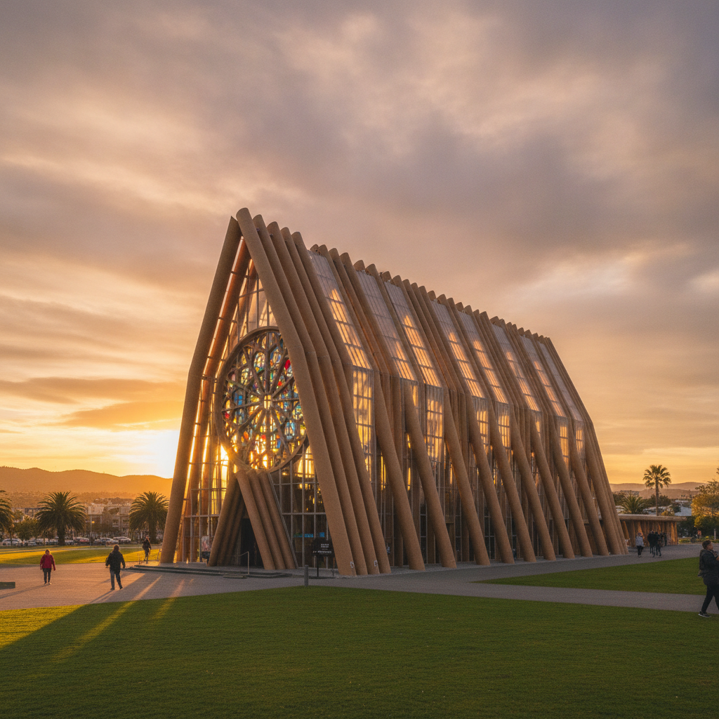
- 6
Christchurch Food, Arts and Architecture of the Post-Earthquake City
The Christchurch food and hospitality scene: the earthquake paradoxically created space for a new and more innovative food culture, as younger chefs and hospitality operators took advantage of lower rents in the rebuild areas. The Christchurch farmers market at Riccarton House (the original Canterbury homestead, Saturday morning): one of the finest farmers markets in New Zealand, with Canterbury lamb, Canterbury wine, artisan cheese, and fresh vegetables. Little High Eatery (the Christchurch food court concept): the multi-vendor food hall model that replaced the old food court with individual chef-operated stalls. The Riverside Market (on the Avon River, opened 2019): the major new food and retail market as part of the Christchurch central city rebuild anchor projects. The Christchurch Art Gallery Te Puna o Waiwhetu: the primary public art gallery, designed by the Buchan Group with a dramatic undulating glass facade; reopened in 2015 after being used as Civil Defence headquarters during the earthquake response. The Cardboard Cathedral (Transition Cathedral, by Shigeru Ban): the temporary cathedral built from cardboard tubes and structural timber, opened August 2013, designed as a temporary replacement for the earthquake-damaged Christchurch Cathedral; it has become an architectural landmark in its own right.