Cairns: Mission Beach Cassowary Country and Tully River Rafting, Port Douglas Upmarket Reef Base, Cape York Wilderness and Quinkan Rock Art, Torres Strait Islands and the Mabo Native Title Decision, Savannah Way to Darwin, Three-Route Tropical North Queensland Verdict
Cairns extended: Mission Beach (southern cassowary, Dunk Island, Tully white water rafting), Port Douglas (Four Mile Beach, Agincourt Ribbon Reefs, rainforest habitat), Cape York Peninsula (northernmost tip, Quinkan rock art 30,000 years old), Torres Strait Islands (Mabo decision, Thursday Island, Torres Strait Islander culture), Savannah Way and Gulf Country road trip, and the complete Cairns tropical north Queensland verdict.
- 1
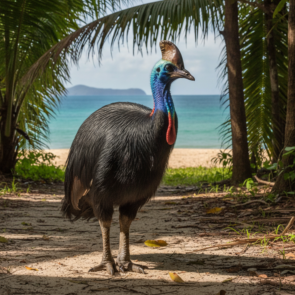
Mission Beach - Cassowary Country and Dunk Island
Mission Beach (approximately 140 km south of Cairns, 2 hours by road): the small coastal community on the Coral Sea at the closest point of the Queensland coast to the outer reef (only 45 km to the outer reef wall). Mission Beach character: the small community of approximately 1,000 permanent residents split across four villages (Bingil Bay, Mission Beach, Wongaling Beach, and South Mission Beach), known for the rainforest walks, the cassowary encounters, and the access to Dunk Island. The Dunk Island (the resort island 4 km offshore from Mission Beach, 5 minutes by water taxi): the rainforest island with walking tracks through the Wet Tropics jungle, fringing reef snorkeling, and the Mission Beach Skydive (landing on the beach, with the reef visible as the backdrop during the freefall). The southern cassowary at Mission Beach: Mission Beach is the area with the highest density of southern cassowary in Australia; the birds (1.5-1.8 m tall, weighing up to 85 kg) are regularly encountered on the roads and in the gardens of the Mission Beach villages. The Tully River (25 km inland from Mission Beach): the white water rafting river of north Queensland, with Grade 3-4 rapids fed by the 7.9 m annual rainfall of the Tully area (the highest annual rainfall of any town in Australia).
- 2
Port Douglas - the Upmarket Base for the Northern Reef
Port Douglas (approximately 70 km north of Cairns, 1 hour by road): the most upmarket resort town of north Queensland. Port Douglas character: the town sits on the Four Mile Beach (the long, north-facing beach on the Coral Sea) and the Rex Smeal Park marina, with the Macrossan Street restaurant and shopping strip at the center. Four Mile Beach: the long, gently curving beach of Port Douglas, fringed by coconut palms, with the Coral Sea visible to the north and the Daintree forest hills to the west. The Low Isles (the small coral cay and lighthouse island 15 km offshore from Port Douglas): the primary reef snorkeling destination from Port Douglas (a small fringing reef around the sand cay, accessible by sailboat or catamaran day trip in approximately 1 hour, with excellent coral in calm conditions). Port Douglas reef operators: the Agincourt Ribbon Reefs (the outer reef 90 minutes north from Port Douglas) are accessed by the Port Douglas reef operators and are considered some of the best reef sections accessible from a day trip. The Port Douglas markets (Sunday morning market in Anzac Park): the primary local market. The Rainforest Habitat Wildlife Sanctuary (on the Port Douglas Road): the walk-through sanctuary with free-ranging wildlife, the flamingos, and the cassowary enclosure.
- 3
Cape York Peninsula - Australia Northernmost Wilderness
Cape York Peninsula (the large wilderness peninsula north of Cairns, stretching to the northernmost tip of mainland Australia at Cape York Point, 900 km from Cairns): one of the last great wilderness areas in Australia. The Cape York experience: a 4WD vehicle is essential for the full Cape York Peninsula drive (the Peninsula Development Road, the primary route, is unsealed and accessible only in the dry season May-October); flying to Bamaga and driving to the tip is the quicker alternative. The tip of Cape York (the northernmost point of mainland Australia): the rocky headland at 10 degrees 41 minutes south latitude, 900 km north of Cairns, with the Torres Strait and Papua New Guinea 150 km to the north. The Jardine River National Park (the large national park in the northern Cape York): the wetlands and river systems supporting crocodiles, brolgas, and the Cape York rock wallaby. The Laura Aboriginal Dance Festival (biennial, in June of even-numbered years, at Laura, 330 km north of Cairns): the largest gathering of Indigenous cultures in Australia, with up to 20 clan groups performing traditional dances. The Quinkan Rock Art (at the Quinkan and Regional Cultural Centre, Laura): the gallery sites of the Quinkan spirit figures in the sandstone caves of the Laura area: one of the most significant Aboriginal rock art collections in the world, with paintings estimated to be 15,000-30,000 years old.
- 4
Torres Strait Islands - Australia Northernmost Communities
The Torres Strait Islands (the group of 274 islands in the strait between Cape York and Papua New Guinea): the home of the Torres Strait Islander people, one of the two distinct Indigenous peoples of Australia (the other being Aboriginal Australians). The Torres Strait Islander culture: a maritime culture that is distinct from mainland Aboriginal culture, with strong Melanesian influences from Papua New Guinea; the Torres Strait Islander people are primarily descendants of Melanesian peoples who settled the islands over the past 2,000-3,000 years. The Torres Strait Island communities: 17 of the 274 islands are inhabited; the primary islands are Thursday Island (TI, the administrative center of the Torres Strait, accessible by ferry or plane from Cairns), Horn Island, Murray Island (Mer), and the Outer Islands. Thursday Island (TI): the commercial and government hub of the Torres Strait, with the Japanese Cemetery (the memorial to the Japanese pearl divers who died in the Torres Strait pearl diving industry, 1890s-1940s), the Prince of Wales Hotel, and the Torres Strait Heritage Museum. The Torres Strait Islander flag (designed by Bernard Namok in 1992): the green, black, and blue stripes with the white five-pointed star (the Dhari, the traditional headdress) at the center. The Mabo decision (1992): Eddie Mabo, from Murray Island in the Torres Strait, was the lead plaintiff in the landmark High Court case that overturned the terra nullius doctrine and established native title in Australian law.
- 5
Cairns to Darwin - the Gulf Country and Savannah Way
The Savannah Way (the 3,700 km road from Cairns to Broome, through the Gulf of Carpentaria, the Northern Territory, and the Kimberley): one of the great Australian road trips, covering the northern savannah woodlands and the tropical wetlands. Key stops west of Cairns: Undara Volcanic National Park (approximately 275 km southwest of Cairns): the Undara Lava Tubes — the longest lava tube system in the world (approximately 160 km of tubes formed by the lava flow of the Undara Volcano approximately 190,000 years ago), with the guided tours through the collapsed sections. The Gulf of Carpentaria: the shallow, vast inland sea of the Gulf Country, with the barramundi fishing (the Gulf streams are the most productive barramundi fishing waters in Australia), the Gulflander train (the heritage rail service from Normanton to Croydon), and the fishing towns of Karumba and Normanton. The Gulf Country wetlands: the Staaten River National Park and the Lawn Hill National Park (Boodjamulla) — the oasis gorge in the dry outback, with the freshwater crocodile (the smaller, less dangerous cousin of the saltwater crocodile), the rock wallaroo, and the ancient limestone gorge walls painted with Aboriginal art. Darwin (the Northern Territory capital, approximately 3,000 km from Cairns by road or 2 hours by air): the gateway to Kakadu, Litchfield, and the tropical Top End.
- 6
Cairns Three-Route Complete: Tropical North Queensland Verdict
Cairns three-route complete summary. Route 1: Great Barrier Reef diving and pontoon tours, Daintree and Cape Tribulation, Kuranda Scenic Railway and Skyrail, Atherton Tablelands waterfalls and crater lakes, practical guide. Route 2 (this route): Mission Beach and cassowaries, Tully River white water rafting, Port Douglas upmarket reef base, Cape York wilderness, Torres Strait Islands (Mabo decision heritage), Savannah Way and Gulf Country. Cairns final verdict: the gateway city that punches significantly above its weight as a visitor destination. No other city of 170,000 people in Australia has access to two UNESCO World Heritage Sites (and two of the most significant on earth: the Great Barrier Reef and the Wet Tropics). The combination of the reef experience (diving, snorkeling, sailing), the rainforest experience (Daintree, Cape Tribulation, Kuranda), the cultural experience (Gimuy Walubara Yidinji, Torres Strait Islander heritage, Quinkan rock art), and the adventure sports (Tully rafting, skydiving, bungy) makes Cairns uniquely dense in visitor value for its size. The reef bleaching is real and significant; visit soon and snorkel or dive in the most pristine sections. Allow 5-7 days for the Cairns region minimum.