Boise: Foothills Mountain Biking, Hells Canyon, Snake River Valley Wine, Garden City Arts, Shoshone Falls, and Growth
Boise: Foothills (190km trails 1.5M uses/year Ridge to Rivers partnership, Hulls Gulch Reserve Crestline 21km Sidewinder technical, Camels Back Park off-leash dog foot of Foothills, top 5 US mountain biking cities Biking Outside Magazines, 9-month trail season March-November low elevation, Bogus Basin summer bike park lift-served June-October most vertical drop per dollar Pacific NW), Hells Canyon (250-300km NW Idaho-Oregon border deepest gorge North America 2,436m vs Grand Canyon 1,857m, He Devil Mountain 2,762m Snake River 326m, HCNRA 1975 650,000 acres, jet boat tours 5-day Class IV-V float most dramatic Idaho after Middle Fork Salmon, Seven Devils named deadly sins, 217,000-acre wilderness floatplane trail or river only access), wine (Snake River Valley AVA April 2007 3.2M acres 900-1,100m volcanic loam highest-elevation east Cascades, Ste. Chapelle 1976 oldest winery 300 acres 70,000 cases, Hells Canyon Winery best-in-class Syrah, Cinder urban winery Garden City arts district, 30+ craft breweries), Garden City arts (River Street 36th-44th former industrial, Surel Mitchell Live-Work only Idaho artist residency, Mitchell 1990s vision creative community foundation, creative industries 12,000 Boise metro, Treefort effect regular Pacific NW tour stop, Boise Contemporary Theater 2001 LORT 190 seats world premieres), Shoshone Falls (220km east Twin Falls 62m tall 274m wide taller than Niagara 52m horseshoe basalt, most dramatic April-June 2,000-3,000 m3/s, late summer 50-100 m3/s partially dry, Perrine Bridge 148m 7th highest US only bridge BASE jumping legal year-round no permit 500 jumpers/year), growth (770,000 metro 2023 projected 1M by 2030, 5 fastest-growing US metros 2016-2024, 40% from California 15% Washington, 206 days sunshine USD 450K median home vs USD 750K+ Portland Seattle, Idaho flat 5.8% income tax, home prices 80% 2019-2022 most rapid major metro, Arrowrock Dam 1915 107m tallest world when built, 30-40% less snowpack by 2050).
- 1
The Boise Foothills and the Mountain Bike Capital of the West
The Boise Foothills (the semi-arid sagebrush hillside immediately north of Boise, rising from 870 m at the city edge to 1,800 m at the Boise Ridge, with 190 km of dirt trails managed by the Ridge to Rivers trail consortium -- a partnership of Ada County, Boise City, and the Bureau of Land Management): the mountain biking and trail running resource that is the most significant driver of the active outdoor lifestyle identity of Boise, with approximately 1.5 million trail uses per year. The trail system: the Foothills trail network is divided into beginner (Lower Hulls Gulch Interpretive Trail, 2.5 km, ideal for families), intermediate (Crestline Trail, 21 km), and advanced (Sidewinder and Hulls Gulch, technical singletrack) terrain, with the Hulls Gulch Reserve (at 2639 North Bogus Basin Road, trailhead) as the primary access point. The Camels Back Park (at 1200 Heron Street, Boise, at the foot of the Foothills, with off-leash dog area and picnic shelters): the most popular neighborhood park in Boise, with 3 km of nature trails connecting to the Foothills trail system. The Boise mountain biking identity: Boise is consistently ranked in the top 5 American mountain biking cities by Biking Magazine and Outside Magazine, driven by the year-round (or near-year-round) trail access (the low-elevation Foothills trails are typically snow-free from March through November, a 9-month season) and the proximity of world-class technical trails within 15 minutes of downtown. The Bogus Basin summer bike park (see Route 1): the lift-served downhill mountain biking and pump track at the summit of Bogus Basin, operating June through October, with the most vertical drop per dollar of any lift-served bike park in the Pacific Northwest.
- 2
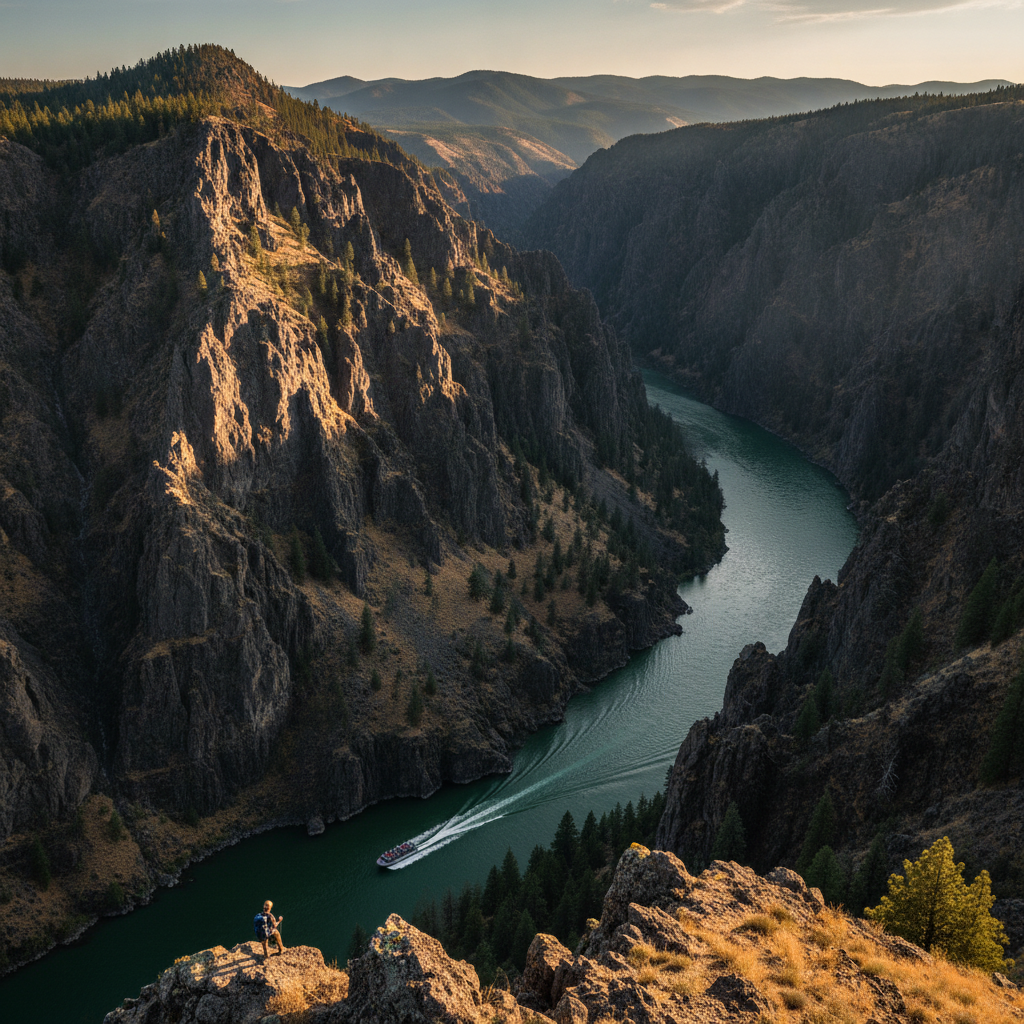
Hells Canyon - The Deepest Gorge in North America
Hells Canyon (the canyon of the Snake River on the Idaho-Oregon border, 250-300 km northwest of Boise): the deepest river gorge in North America, reaching a maximum depth of 2,436 m (from the summit of He Devil Mountain in the Seven Devils Mountains on the Idaho side at 2,762 m above sea level to the Snake River surface at 326 m above sea level -- a vertical difference deeper than the Grand Canyon at its deepest point of 1,857 m). The Hells Canyon National Recreation Area (at 401 Highway 82, Enterprise, Oregon, with the primary access from Lewiston, Idaho, 450 km north of Boise, or from Oxbow, Oregon, 350 km northwest of Boise, established 1975, 650,000 acres): the recreation area managed by the U.S. Forest Service with jet boat tours from the Hells Canyon Dam (the southern end of the protected canyon), whitewater rafting on the Class IV-V Snake River (a 5-day wilderness float from Hells Canyon Dam to Lewiston, the most dramatic river trip in Idaho after the Middle Fork of the Salmon), and hiking the Snake River Trail. The Seven Devils Mountains (the Idaho mountain range above the canyon, with He Devil as the highest at 2,762 m): the most dramatically positioned mountain range in Idaho, rising from the canyon rim in a series of serrated peaks named (by early prospectors) after the seven deadly sins. The Hells Canyon jet boat tours (operated by multiple companies from Lewiston and Clarkston, Washington, 450 km north of Boise): the most accessible way to experience the canyon without rafting or hiking, with 1-day and 2-day tours reaching the most remote sections of the canyon. The Hells Canyon Wilderness (217,000 acres): one of the most remote wilderness areas in the Pacific Northwest, accessible only by trail, river, or floatplane.
- 3
The Treasure Valley Wine Region and Craft Beverages
The Snake River Valley American Viticultural Area (the designated wine region of southwestern Idaho, established as an AVA by the TTB in April 2007, covering 3.2 million acres in the Snake River valley from the Boise area east to the Magic Valley): the highest-elevation wine-growing region east of the Cascades in the Pacific Northwest, with vineyards planted at 900-1,100 m in volcanic loam soil. The region produces primarily Rhone and Bordeaux varieties (Syrah, Merlot, Cabernet Sauvignon, Chardonnay, Riesling), with Syrah producing the most critically distinctive wines due to the extreme diurnal temperature range (warm days, cold nights) that slows ripening and produces wines with intense color, high tannins, and complex fruit. The Ste. Chapelle Winery (at 19348 Lowell Road, Caldwell, ID, 50 km west of Boise, established 1976 -- the oldest winery in Idaho, with 300 acres of vineyards): the largest winery in Idaho and the founding institution of the Idaho wine industry, producing approximately 70,000 cases per year. The Hells Canyon Winery (at 18835 Symms Road, Caldwell, ID, adjacent to Ste. Chapelle): the premium Idaho producer focused on Syrah and red Bordeaux blends, with wines that have won best in class at Pacific Northwest wine competitions. The Cinder Winery (at 107 East 44th Street, Garden City, ID, adjacent to Boise, in the Surel Mitchell Garden City arts district): the urban winery that processes Snake River Valley fruit in a downtown Boise-adjacent location, with a tasting room in the Garden City arts corridor. The craft beer scene: more than 30 craft breweries in the Boise metro, with Woodland Empire Ale Craft (at 3620 Osage Street, Boise), Cloud 9 Brewery (at 11724 West President Drive, Boise), and 10 Barrel Brewing Boise (at 826 West Bannock) as the most notable.
- 4
Garden City Arts District and the Boise Creative Economy
The Garden City Arts District (in Garden City, the small city adjacent to and north of Boise along the Boise River, the River Street area between 36th and 44th Streets): the most concentrated arts and creative industry district in Idaho, developed since approximately 2010 in the former industrial buildings along the Boise River, with glass studios, ceramics studios, woodworking shops, photography galleries, wine tasting rooms, and the Surel Mitchell Live-Work Artist Residency (the only live-work artist residency in Idaho, providing housing and studio space to artists in residence). The Surel Mitchell Art Foundation (named for Surel Mitchell, the Boise artist and community organizer who created the Garden City arts community from a vision she articulated in the 1990s): the foundation that manages the residency and the garden-and-studio complex along the Boise River in Garden City. The Boise creative economy: the creative industries (arts, music, film, design, architecture, marketing) employ approximately 12,000 people in the Boise metro, with the tech industry growth generating substantial demand for creative services. The Treefort expansion effect: since Treefort Music Fest established Boise as a nationally known music destination in 2012-2015, the number of recording studios, music-related businesses, and touring bands making Boise a tour stop has grown substantially -- Boise is now a regular stop on Pacific Northwest touring circuits that previously ended at Portland or Seattle. The Visual Chronicle of Idaho project: the Idaho Commission on the Arts initiative to document Idaho visually through commissioned art and photography. The Boise Contemporary Theater (at 854 Euclid Avenue, Boise, founded 2001, a LORT (League of Resident Theatres) member): the professional theater company presenting world premieres and contemporary drama in a 190-seat thrust theater.
- 5
Shoshone Falls and the Magic Valley
Shoshone Falls (on the Snake River at 4155 Shoshone Falls Grade, Twin Falls, ID, 220 km east of Boise on I-84): the largest waterfall by volume in the American West and one of the most dramatic natural landscapes in the continental United States -- a horseshoe-shaped fall 62 m tall and 274 m wide (taller than Niagara Falls at 52 m and wider than Niagara at its 1,240 m widest) that drops the Snake River over a shelf of Pleistocene basalt into a pool below, with the surrounding canyon walls of dark basalt rising 91 m above the river. Shoshone Falls is called the Niagara of the West, though it is in the same geographical province (the Columbia Plateau) as Palouse Falls (57 m) and others. The flow: Shoshone Falls is most dramatic April through June, when Snake River flows from snowmelt peak at 2,000-3,000 cubic meters per second; by late summer (August-September), irrigation diversions reduce the flow to 50-100 cubic meters per second and the falls may be partially dry. The Magic Valley (the irrigated agricultural region surrounding Twin Falls, 220 km east of Boise): the region transformed from high desert by the completion of the Milner Dam in 1905 and the subsequent development of one of the largest irrigation systems in the United States, drawing from the Snake River and the Eastern Snake Plain Aquifer to irrigate 600,000 acres and produce dairy, potatoes, grain, vegetables, and one of the most productive agricultural regions in the Pacific Northwest. Perrine Bridge (at the junction of US-93 and the Snake River canyon, Twin Falls): the 148-m-high bridge over the Snake River Canyon (the 7th highest bridge in the US), famous as the only bridge in the United States where BASE jumping is legally permitted year-round without a permit -- approximately 500 BASE jumpers per year use the bridge.
- 6
Boise's Rapid Growth and the Future of a Western City
Boise's growth trajectory: the Boise metropolitan statistical area (population 770,000 in 2023, projected 1 million by 2030) has been among the 5 fastest-growing metros in the United States every year from 2016 through 2024, driven by inbound migration from California (approximately 40% of new residents), Washington (15%), and Oregon (10%) -- remote workers, retirees, and families priced out of the coastal Pacific Northwest markets. The growth drivers: the combination of a warm, sunny climate (206 days of sunshine per year), affordable housing (median home price approximately USD 450,000 in 2024, compared to USD 750,000+ in Boise's west coast feeder markets of Portland and Seattle), the outdoor recreation lifestyle, a growing technology economy (Micron, HP, Clearwater Analytics), and low state taxes (Idaho has no city income tax and a relatively low state income tax of 5.8% flat rate) have made Boise the premier migration destination of the American West. The housing affordability crisis: the same growth that has brought economic vitality has priced many long-term Boise residents out of the market -- median home prices rose 80% from 2019 to 2022, the most rapid increase of any major metro. The water future: Boise's growth is constrained ultimately by the same factor that constrains all western cities -- water. The Boise area is served by the Boise Project (the Bureau of Reclamation irrigation system built 1903-1912 with the Arrowrock Dam (completed 1915, the tallest dam in the world at the time at 107 m)), Lucky Peak Dam (1955), and Anderson Ranch Dam (1950), storing the Boise River's annual snowmelt runoff. Climate change is reducing the average snowpack by 1-3% per year, with 2050 projections showing 30-40% less snowpack in the Boise River watershed -- a direct threat to the water supply of a city growing by 20,000 per year.